He described the overview of the region and what he's involved with. He highlighted the region's Randstad Rail, cycling policy, physical planning and public transport, and Integral Planning.
An example of Integral Planning is the consideration that the Dutch must have for where water goes. Considering that much of the country is below sea level this is critical.
Population and Land Area - Details of the Hague
He described the Netherlands and compared it to the population and land area of Massachusettes, Conneticuit, & Rhode Island. From Wikipedia.| Area(2006) | |
| • City andmunicipality | 98.20 km2(37.92 sq mi) |
|---|---|
| • Land | 82.66 km2(31.92 sq mi) |
| • Water | 15.54 km2 (6.00 sq mi) |
| Population (1 February 2012) | |
| • City andmunicipality | 501,725 |
| • Density | 5,894/km2(15,270/sq mi) |
| • Urban | 1,022,256 |
| • Metro | 1,406,000 |
He also indicated that there are 15.3 sq. km of Industrial estates and 35 sq km of greenhouses.
Regional Planning Over Time
The regional government is guided by the intent to "Do local what can be done local, Do regional what must be done regional", suggesting that there are some communities that aren't large enough to have the expertise to serve a community effectively. [My experience in private practice indicated that there was wide variety of expertise in government agencies of all sizes].
Jan described the history of planning based on his 30 years experience. In the 1970s and 1980s he indicated that the Dutch had a policy of "Bundled Deconcentration" with new light rail lines in Rotterdam, Den Haag, and Utrecht. There were more cars during this period and larger houses. They used selective urban renewal which included displacing people.
In the 1990s there was a shift to build at the edge of the cities and extend urban railways systems. There was quite a bit of effort to complete traffic demand management measures. People didn't like the demand management portion, so when there was success there was a change in how the policy was communicated. Jan introduced the ABC land use zoning with A being the type of office that you can easily serve with transit and C being auto focused development. They began using their ABC location policy of offices being very important to be near rail stations and recognizing that not all development needs to be well served by rail or public transport and finding success. They have been very good in recognizing the importance of this and integrating bicycle use throughout all different types.
In the 3rd Millenium, he characterized the lack of money for investment and public transport operations. There is a more business like approach of public transport and reuse of existing
Their goals is to include 60-80% of new housing within close proximity of high quality transit lines. An example of this is that the new Delft rail station will be 1,500 housing units and a City building integrated there as well.
History of Community Planning in the Haaglanden
Pijnacker in 1950 was a small community, "village" on the rail line between Den Haag and Rotterdam. Nootdorp was off the rail line but in between Den Haag and Pijnacker.Zoetermeer was a new town in 1965 when there was recognition of the need for more housing and became a much larger urban area. The planners focused a significant energy around that area and there were several areas to the southwest of Den Haag and Tanthof.
He indicated that it was not a good development because there were limited jobs in Zoetermeer, so people had to travel. It was also too far away to make cycling a reality (Dutch range of cyclists is 12 km away), and few people are biking to their jobs. Zoetemeer is off the major rail line between Den Haag and Rotterdam, so it only has a rail connection (spur line) to the central city and the frequency was not high enough because there were not enough people at the Den Haag Central Station to make it attractive.
The central city of Zoetemeer also suffered from lower densities than most of the communities. Most of the development were 2 stories. There were a few 20-story buildings, but they weren't very popular.
Ypenburg was built in 1995 and was a former Air Force Base. The community included an expansion of the existing tram system into the system and there was also a new railway station on line between Utrecht and Den Haag. Being on the major rail station gives Ypenburg a distinct transportation advantage (for serving non-auto trips). It is also only 5km from The Hague, so cycling is an option for more of its residents in getting to work.
Future plans from Zoetermeer is to reconstruct the heavy rail line to be part of Ranstad Rail so that there is more local service and it is a more comprehensive system. The smaller vehicles offer cheaper service and there can be higher frequencies. The light rail trains have better accel and decel properties, so overall Jan felt it was a higher quality of service for accessibility.
Future of Planning and Public Transport
There's a recognition of some of the missteps from the past and energy is being focused on using operations at stations along public transport lines. There interest currently in developing along exsting railways and trying to avoid office developments in decentralized locations.Peter Furth indicated that in Boston, the suburban communities are fighting for office space because they pay additional taxes than residential property and they don't send children to schools (which the locals have to pay for as well). The Hague doesn't seem to have any issues that are similar to this.
Jan described the current focus on Integrating Public Transport into community. There are 8 principles:
All areas have a direct PT link with city center and one of two main railway stations
All stations have one or more light rail with stops near the main entrance.
All homes have a PT stop at a maximum distance of 500m
Trams have high frequencies, so transfer is no problem
All railway stations and many tram stops have bicycle parking facilities.
Many railway stations have park and ride facilties
Bicycles in trams are not permitted, in light rail only after 7:00 PM and in weekends
Popular OVfiets (PT bike) system: www.ov-fiets.nl will be integrated at each station.
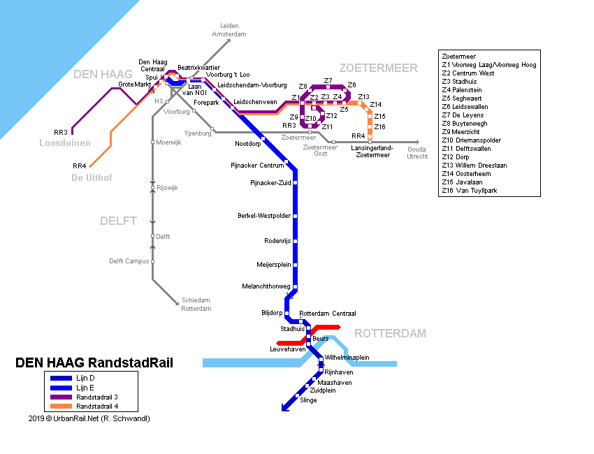
Jan summarized the Randstad Rail system map and how it influenced the planning. I haven't actually used the tram during my time in Delft. I have used the bus, but not the tram. The map of the Delft Line 19 that is being expanded to the TU Delft campus.
Enough summarizing the presentation. It's now time for the tour of the community!
No comments:
Post a Comment