Thursday, September 30, 2010

Shibuya Pedestrian Scramble

I took the Hanzomon Line from Nagatacho to Shibuya at about 8:30 PM upon arrival and found a traffic engineer's nightmare. In the picture, there are pedestrians everywhere streaming from all directions imaginable in what seems to be lightly organized chaos. My neighbor described it as Times Square multipled by ten, but I am inclined to give Times Square a little more credit because of the size of the buildings. Needless to say however, this is one amazing intersection and the surrounding neighborhood is like one large department store. 
!
Posted by Picasa

ITS makes Bicycling Safer in Japan (or not)

I have been noticing that my blog has resembled a bicycle focused one and so it felt time to get back to that theme with a perspective from a Japanese researcher from the Mazda Corporation. This gentleman works in the Chugoku prefecture which is where Hiroshima is. As an American citizen and a product of the Portland Public School system and a college educated Engineer, I have had sadly little experience with the geography of Japan. Always too busy studying math problems. But that's beside the point, which is the researchers evaluated using sensors to identify whether people on bicycles were travelling on the major street (over a bridge, down the grade) and if by detecting them, they could share this information with the driver of the vehicle through a Infrastructure to Vehicle communication. There was also a pedestrian application to the right of the bicycle picture that was something that I have interest in.
Yet, just like in the U.S. that wasn't funded. The little green line on the bottom of the shows that the ones to the right are not part of the initial effort. They are working on stop sign awareness, which to me (just like the U.S) seems like an effort that doesn't offer enough risk exposure to warrant the research AND the infrastructure is expensive becuase there is no place to get power at most of these intersections like there is at our traffic signals.
Posted by Picasa

UTMS Japan Conference at UN University

Attending the UTMS Conference gave me a new appreciation for diplomacy. The presentations for the conference were given at the United Nations University building here in Tokyo. The auditorium had translators working busily as the presenters gave their Powerpoint sessions, so I was in luck. There was a one ear listening device that allowed me to follow the information quite easily. They also provided translated slides in a printed format, which was also helpful. In all, I have found the Japanese very accomodating, which made the time engaging because we share challenges as transportation professionals. I was very fortunate to have a few presentations in advance of mine to learn about what sorts of things they are working on at Saitama University and the National Policy Agency of Japan. One particular item of interest is that the Police agencies are the operators of the traffic signal system and the private companies are involved in the product development and supporting those Police Agencies in the delivery of transportation services. This is very different than in the U.S. where the Department of Transportation is mostly engineers and other public agency staff that are not necessarily run like the police. My hosts at UTMS are from the private sector and over dinner I learned a lot more about the makeup of UTMS. Best I can tell, it is very similar to our Transportation Research Board, yet the staff of the agency appear to be paid by the private companies. I imagine some of this is lost in translation.
I didn't ask for my host to take a picture while I was providing the presentation, but once I was complete, I did stop after a break and get a quick photo. The auditorium was quite large (over 300 people) and I found the stage with the lighting a bit daunting, but not overly so. Surely, no one was going to challenge what I was saying because it would be a one way communication. Yet, I tried to be somewhat provocative suggesting that in Portland we're aggressively working on Climate Change. This was actually acknowledged by the professor at Saitama University who noted Portland's work on promotion of bicycle travel and his own observations that the younger population in Japan is more open to carsharing and less likely to own a car.
Following the presentations, there was a panel discussion regarding the "Expectations of Cooperative Systems", which meant how would data from on board automobile units be used in traffic control and combined with the data we recieve from sensors that are currently in the transportation infrastructure.
In Japan, they have invested considerably in infrared sensors that are mounted above the travel lanes. We have a lot of different applications in the U.S. that we might not be doing very well with any of them. Yet, it wasn't clear how well the infrared was serving them here and some of the research was describing the use of Dedicated Short Range Communications (DSRC) to support additional functions that were desired from the traffic control system. Obviously, there's a lot of geeky considerations going on in my head while I am taking pictures of various things throughout the city streets.
Posted by Picasa

Wednesday, September 29, 2010

Tokyo Transportation Observations

Variable message sign for arterial traffic. It appears to be displaying some sort of routing information.
The arterial are fairly wide, yet they seem to have very fine distinctions between these streets and when you enter into a neighborhood.
The intersections are fairly straight forward and similar to ours. The signal heads appear to be displayed quite a bit differently and I need to spend some time to sort out the horizontal display and the additional signal heads. It doesn't appear they use flashing yellow arrows (at least from what I can see thus far).
The following pedestrian indication shows a don't walk indication AND a relative time to Walk "countdown" the bars on the display to the right of the pedestrian indication show how long until it will go WALK. It also lights up only when the button is pushed, thus it is a nice confirmation that the call has been registered.
The freeway system is fairly well developed and is a mix between freeways, grade separated arterials, and busy streets.
Posted by Picasa

UTMS Japan - Tokyo Visit


I am in Tokyo to present information about how the City of Portland is using traffic signals to reduce our environmental load. The presentation is approximately 18 hours from when I landed at Narita airport, so I may not be at my best without another cup of coffee!

Here are the initial pictures from my visit. The first photo is the view from my hotel room which is the Grand Prince Hotel Akasaka. I am on the 35th Floor and the room is spacious and comfortable. The view is very nice and I am close to the Imperial Palace and the Nagatacho Station on the Hanzomon Line. It's a great spot to start the visit.
I have brought gifts for my hosts as is customary in Japan. I found some great things to put in the Made in Oregon bag including candleholders made from recycled bike parts from Resource Revival, a variety of chocolate covered treats from the Made in Oregon store, chocolate covered coffee beans from Coffee People and coffee from Portland Roasting. I got a book from Powells at the airport that includes aerial photos of Portland and its surroundings, so I think this will be recieved well.
The initial perspectives I have on arrivals is that Tokyo is a late night town. I awoke at 5:30 AM today and was on the streets by 6. Walking around I found there weren't many shops open until 7 AM, even the coffee shops and no one has free WiFi. I am stuck paying $20 equivalent at the hotel! There was a rumor that McDonalds had free WiFi, but it turned out false (at least the one that I went to).
I am doing a bit of catch up with work email as well since I am travelling on behalf of the City and am grateful for the opportunity to participate in this exchange.
I am keeping an eye out for transportation facilities as always and found a few things that are worth considering for Portland.
The first example was a cross bike (adjacent to the crosswalk) that creates some facilities for people on bicycles that wouldn't otherwise have a connection clearly delineated. I'd be interested in their practice for implementation and when they choose to do this off-street and when on-street. I probably won't have much opportunity to talk with bicycle planners at this conference, since is primarily technology related.
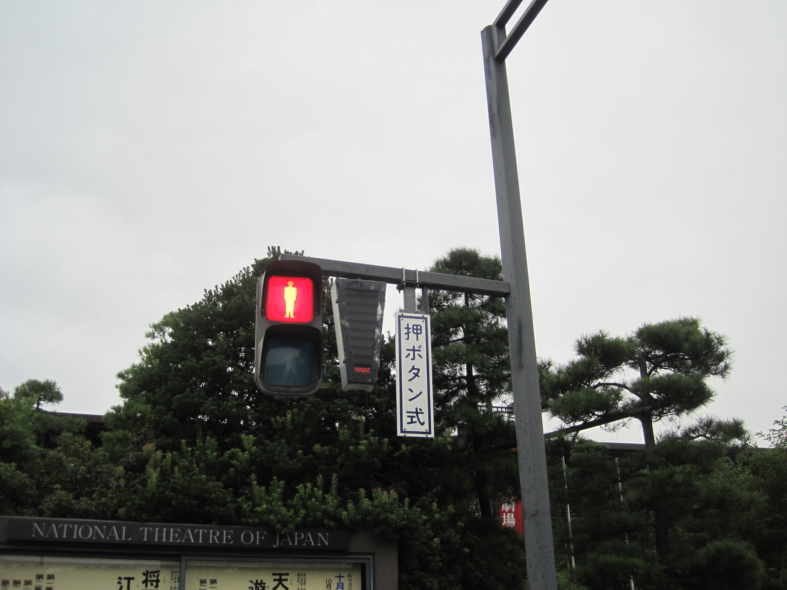
The pedestrian indications are a mixed bag and they may be in the transition phase between the old style, which appear to be backlit light blue signs for walk and red don't walk indications. It appears they are going to a green walking person and a red don't walk. They flash the Walk indication to indicate when to clear the intersection, which is slightly different from our message. It does make me wonder whether we should flash the Walk when it is becoming stale and you're close to changing. It's a pretty small change that could improve information for peds.
They also add a sign adjacent to the pedestrian indications which I can't translate. I will ask about this at the meeting.
Posted by Picasa

Monday, September 20, 2010

At Beckman Center In Irvine for a Workshop

U.S. DOT is asking the question: How do we measure and evaluate livability and environment-related goals?
I find it ironic that we are in Irvine, CA to discuss this, where every street seems to be at least 6 lanes and there was limited public transit opportunities to speak of. In this picture, there appears to be a bicycle path adjacent to the six lane, so at least they have that going for them.
We are at the Beckman Center, which is at the end of a cul de sac on the University of California-Irvine campus. It's a nice facility and the weather is great, but... it's not a great model for urban design.
I am pleased that USDOT is asking the questions and am looking forward to trying to provide answers in the future.
Posted by Picasa

Sunday, September 5, 2010

Washington DC Ped Bike Innovations

 
Just returned from Washington DC, (I am serving on a National Cooperative Highway Research Program Panel 3-103) and while there enjoyed seeing a few new pedestrian and bicycle related innovations that are new as of my last visit to the Verizon Center/Chinatown neighborhood and Pennsylvania Avenue. The first example was a pedestrian scramble, which makes sense when there is so many people walking around. I am asked about installing these on occasion and there might be a few locations where it would make sense in Portland, but it would increase delay for pedestrians and have to be outside of the normal operations, which would make it hard to operate.
 
The two way center running bike facilities are very nice and make Pennsylvania Avenue a little bit more friendly as a street. The street is super wide, so making this happen was a snap because they simply took some width out of what was otherwise three super wide lanes in each direction. The design of the intersections and the traffic signals are a little challenging, they have placed bollard strategically to make them work. I need to determine whether I have some before pictures, which would be an interesting comparison.
 
Posted by Picasa