I got an email from another colleague regarding the experience converting a 4-lane to 3-lane conversion on NE 12th Avenue. I could spend a lot of time to describe it or I could summarize blog posts that BikePortland.org had on the subject in chronological order with better reporting than I could accomplish at home in the evenings after work.
Pushback on the Plans - are signals enough? - April 28th: This was the time I got involved. There was some earlier work on the concepts, but I hadn't done a whole lot of new information.
Implementation Notice - June 2nd: PBOT implemented the signal changes with some striping modifications before the school year ended.
Moving Forward with Concerns - June 16th: A second meeting was held to discuss initial results.
Consensus with the Stakeholders! - September 29 : We studied the after when school was back in session to do a reasonable comparison.
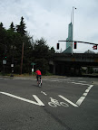
Implementation pictorial: The completed project, we still have a few things to modify and we committed to evaluate the after before the end of the year. We haven't had any complaints that we were not able to address.
Showing posts with label ITS. Show all posts
Showing posts with label ITS. Show all posts
Monday, February 27, 2012
Monday, February 6, 2012
Peter Koonce Bio Updated to 2012
Peter Koonce, P.E., is the Manager for the City of Portland Bureau of Transportation's Signals, Street Lighting, & ITS Division. Prior to serving with the City, he worked with Kittelson & Associates, Inc. He has served as an adjunct professor at Portland State University Netherlands with Northeastern University and the Technical University in Delft Institute of Transportation Engineers
Tuesday, January 10, 2012
Green Wave Signal Timing in Copenhagen with Transit
A great conversation with a consultant who is working on modifying the Green Wave signal timing to incorporate transit priority measures that will reduce delay for buses. In describing the two Green Wave projects we have implemented in Portland outside of downtown (which is all timed for human scale speeds) we discussed the relative importance of certainty associated with the signal timing and the practical implementation issues associated with what you cannot at the intersectionof two green waves. Our experience in Portland is a little difference because our Green Waves are on one way couplets, which makes the progression issue less of an issue in the opposite direction.
 |
| From One Greenwave unofficially starts at the Bike Signal at Interstate & Oregon |
The person I talked to was also very interested in what we've done with VISSIM to assess bicycles and pedestrians. While we've used some of the elements of simulation, I would say we've just scratched the surface related to what can be done. Beyond the simple assessment of adequacy of the facilities, is the quality of the network to support multimodal travel. There are a lot of details we are not ready to assess to fully evaluate tradeoffs between transit, bike, ped, and freight mobility. Things like the use of detection are difficult to weigh without performance measures and a complete assessment for the 24/7 operating conditions we deal. This is not to mention the maintenance issues associated with the decision of the engineers.
Finally, we discussed detection technology, which is consistent with several posts and a recent inquiry from the Oregonian, BikePortland, and Alta about some work that was done in Pleasonton, CA.
Wednesday, November 23, 2011
Turning Vehicles Yield to Bicycles Dynamic Sign
The City of Portland installed a dynamic warning sign at NE Grand and Couch in Portland during the past week. The intent was to clarify the traffic control at the intersection and to warn motorists of an approaching cyclist. |
| Inductive loop detection is located upstream from the traffic signal by 200 feet. We have second detector in the bike lane approximately 60 feet downstream is used to identify and confirm that all people on bicycles are approaching the signal. |
 |
| The active sign is behind the no turn on red sign and the advance ctop here on red sign. |
 |
| 50' from the intersection you can see the bike box and the active warning sign. The arrow in the bike lane advances. |
 |
| A close up of the sign shows the information. This is the same message as the MUTCD sign with the exception of the bike lane and the bicycle (the MUTCD sign is only for pedestrians). The sign is the same size as the signal head (3' x 3') |
Wednesday, October 19, 2011
Transportation Research Board Paper Acceptance
Sirisha Kothuri, one of the City of Portland's interns over the summer wrote up a paper describing our work to use existing signal controllers to measure delay at traffic signalized intersections. While we were at it we figured out we could collect bicycle counts as well at select locations. Well, I am proud to announce that the paper: "Preliminary Development of Methods to Automatically Gather Bicycle Counts and Pedestrian Delay at Signalized Intersections" was accepted for the 2012 Transportation Research Board Annual Meeting. The authors include Sirisha Kothuri, Titus Reyonlds, Christopher Monsere, and Peter Koonce.
I am sure it will be posted at some point and I will update the post when I find it.
I am sure it will be posted at some point and I will update the post when I find it.
Thursday, October 13, 2011
Roads Going High Tech... and Bicycle Lanes Too
Today's blog from the Secretary of Transportation describes roads going high tech. At yesterdays, TransPort meeting (the Intelligent Transportation Systems Subcomittee of Metro's TPAC) we learned about how the Oregon DOT is going to implement some queue warning signs and additional technology to highlight where highway traffic is stopped and to reduce the speed limit accordingly. It's an exciting development for improving safety and improving our highways (specifically Highway 217 and ) as we seek to do more with our existing infrastructure. This specifically should reduce the potential of wasting capacity that can be restored if motorists are aware of the change. One can debate the extent of the improvements, but putting information in the hands of engineers can yield societal benefits.
Not to be outdone, we're working to pull together information on bike lanes in a similar fashion. The link below shares where the map is and the progress on where we're counting and monitoring use of the system.

UPDATED: I recieved a comment about how we're detecting bikes and that's found here: http://koonceportland.blogspot.com/2011/09/automated-bicycle-counting.html
Monday, August 15, 2011
Green Driver Article
The City has provided data to a company in Eugene that produced the Green Driver ap for Android and iPhone.
It has gotten some press coverage and it seems to work well (where we have communication to the traffic signals which is about 65% of them). The article from Bloomberg describes a variety of different companies in the market and is worth a read.
It has gotten some press coverage and it seems to work well (where we have communication to the traffic signals which is about 65% of them). The article from Bloomberg describes a variety of different companies in the market and is worth a read.
Friday, June 24, 2011
Bicycle Counting Station
Adjacent to City Hall on H.C. Andersens Boulevard is the bicycle counting station that identifies the number of cyclists that have used the cycletrack today and the number that have used it this year. The numbers speak for themselves. I know what it would take to create one of these things and it is very similar to what we've done with the parking garages downtown. 
The problem is that I haven't found an adequate place to put one. Many of our facilities could be subject to vandalism (Springwater corridor) and there is always the problem of getting power to the device.
In the time that we were there, the cyclist count went from 6,399 to 6,403 and that was only 39 seconds. More coverage about this can be found at this posting on the Copenhagenize blog.


The problem is that I haven't found an adequate place to put one. Many of our facilities could be subject to vandalism (Springwater corridor) and there is always the problem of getting power to the device.
In the time that we were there, the cyclist count went from 6,399 to 6,403 and that was only 39 seconds.
 More coverage about this can be found at this posting on the Copenhagenize blog.
Sunday, April 24, 2011
Portland Traffic Day
We have been planning the return of Portland's Traffic Day for over 18 months and look forward to a great list of speakers that will inform the "Traffic Signal" staff around the region. I had a chance to meet with Gail Achterman, our first presenter last Monday over coffee to discuss her role. Gail has been the Chair of the Oregon Transportation Commission, which is a prominent position. Her leadership has presented several exciting opportunities for the our profession and really has a passion for innovation, sustainability, and leadership.
In light of this, I am going to tweet for the meeting using the hashtag #pdxtrafficday as a part of getting the word out about what we're doing.
The presentations also include Lynn Peterson, who was the Clackamas County Chair, but recently joined the Governor's Office as an advisor on Transportation. Lynn will highlight the importance of livability on the work that we're doing.
We'll feature several technical sessions including one on bicycle detection, another on pedestrian advancements, and innovative strategies such as adaptive control. I am very excited about the potential for all of these to improve freight mobility, using the traffic signals to meet the various needs of the context for which we operate. Next year, we need to spend more time on freight priority and I hope to have more presentations like this one from UBC.
Wednesday, October 13, 2010
Another mention of Portland's Signals in the Press
This time a retweet of the old fashioned kind from ITS America, which teamed with Transportation 4 America to highlight a few Signals related pieces that should warrant some attention throughout the Signals world. Press Releases : News and Events
Wednesday, September 29, 2010
Tokyo Transportation Observations
Variable message sign for arterial traffic. It appears to be displaying some sort of routing information.
The arterial are fairly wide, yet they seem to have very fine distinctions between these streets and when you enter into a neighborhood.
The intersections are fairly straight forward and similar to ours. The signal heads appear to be displayed quite a bit differently and I need to spend some time to sort out the horizontal display and the additional signal heads. It doesn't appear they use flashing yellow arrows (at least from what I can see thus far).
 The following pedestrian indication shows a don't walk indication AND a relative time to Walk "countdown" the bars on the display to the right of the pedestrian indication show how long until it will go WALK. It also lights up only when the button is pushed, thus it is a nice confirmation that the call has been registered.
The freeway system is fairly well developed and is a mix between freeways, grade separated arterials, and busy streets.

The arterial are fairly wide, yet they seem to have very fine distinctions between these streets and when you enter into a neighborhood.

The intersections are fairly straight forward and similar to ours. The signal heads appear to be displayed quite a bit differently and I need to spend some time to sort out the horizontal display and the additional signal heads. It doesn't appear they use flashing yellow arrows (at least from what I can see thus far).
 The following pedestrian indication shows a don't walk indication AND a relative time to Walk "countdown" the bars on the display to the right of the pedestrian indication show how long until it will go WALK. It also lights up only when the button is pushed, thus it is a nice confirmation that the call has been registered.
The freeway system is fairly well developed and is a mix between freeways, grade separated arterials, and busy streets.
UTMS Japan - Tokyo Visit

I am in Tokyo to present information about how the City of Portland is using traffic signals to reduce our environmental load. The presentation is approximately 18 hours from when I landed at Narita airport, so I may not be at my best without another cup of coffee!
Here are the initial pictures from my visit. The first photo is the view from my hotel room which is the Grand Prince Hotel Akasaka. I am on the 35th Floor and the room is spacious and comfortable. The view is very nice and I am close to the Imperial Palace and the Nagatacho Station on the Hanzomon Line. It's a great spot to start the visit.
I have brought gifts for my hosts as is customary in Japan. I found some great things to put in the Made in Oregon bag including candleholders made from recycled bike parts from Resource Revival, a variety of chocolate covered treats from the Made in Oregon store, chocolate covered coffee beans from Coffee People and coffee from Portland Roasting. I got a book from Powells at the airport that includes aerial photos of Portland and its surroundings, so I think this will be recieved well.

The initial perspectives I have on arrivals is that Tokyo is a late night town. I awoke at 5:30 AM today and was on the streets by 6. Walking around I found there weren't many shops open until 7 AM, even the coffee shops and no one has free WiFi. I am stuck paying $20 equivalent at the hotel! There was a rumor that McDonalds had free WiFi, but it turned out false (at least the one that I went to).
I am doing a bit of catch up with work email as well since I am travelling on behalf of the City and am grateful for the opportunity to participate in this exchange.
I am keeping an eye out for transportation facilities as always and found a few things that are worth considering for Portland.

The first example was a cross bike (adjacent to the crosswalk) that creates some facilities for people on bicycles that wouldn't otherwise have a connection clearly delineated. I'd be interested in their practice for implementation and when they choose to do this off-street and when on-street. I probably won't have much opportunity to talk with bicycle planners at this conference, since is primarily technology related.
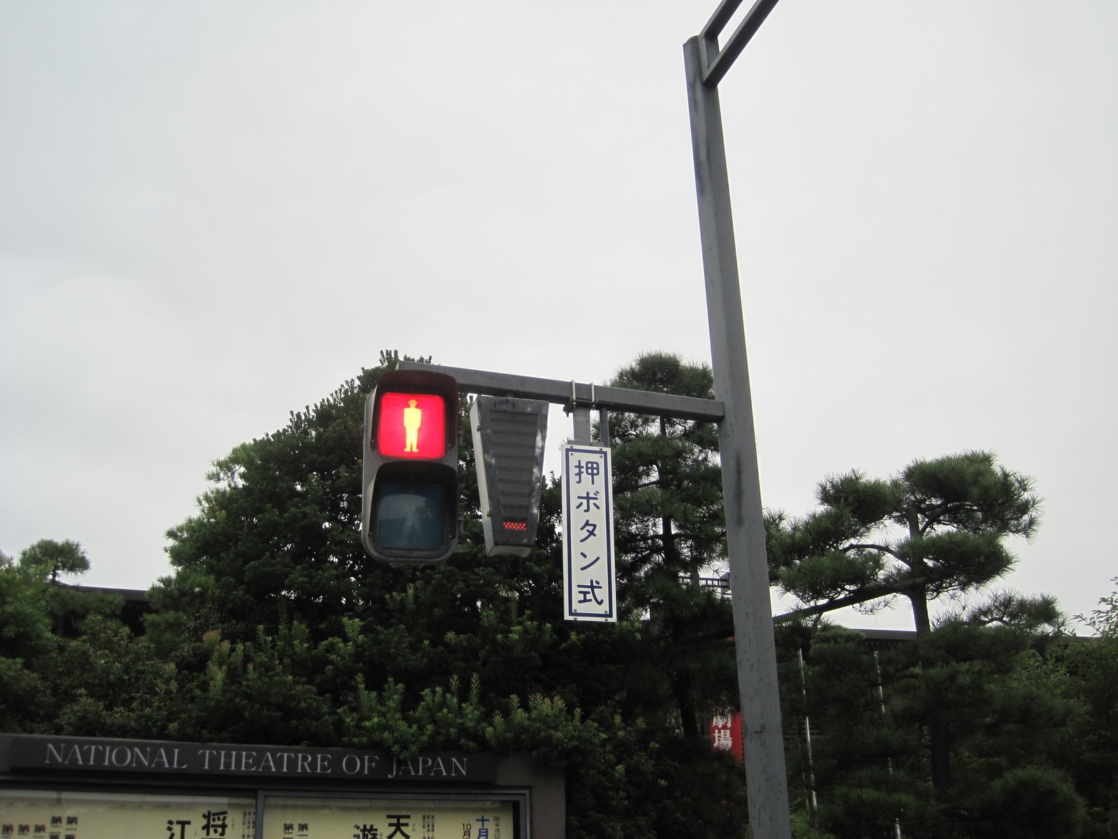
The pedestrian indications are a mixed bag and they may be in the transition phase between the old style, which appear to be backlit light blue signs for walk and red don't walk indications. It appears they are going to a green walking person and a red don't walk. They flash the Walk indication to indicate when to clear the intersection, which is slightly different from our message. It does make me wonder whether we should flash the Walk when it is becoming stale and you're close to changing. It's a pretty small change that could improve information for peds.
They also add a sign adjacent to the pedestrian indications which I can't translate. I will ask about this at the meeting.

Monday, September 20, 2010
At Beckman Center In Irvine for a Workshop
U.S. DOT is asking the question: How do we measure and evaluate livability and environment-related goals?
I find it ironic that we are in Irvine, CA to discuss this, where every street seems to be at least 6 lanes and there was limited public transit opportunities to speak of. In this picture, there appears to be a bicycle path adjacent to the six lane, so at least they have that going for them.
We are at the Beckman Center, which is at the end of a cul de sac on the University of California-Irvine campus. It's a nice facility and the weather is great, but... it's not a great model for urban design.
I am pleased that USDOT is asking the questions and am looking forward to trying to provide answers in the future.
Friday, July 30, 2010
Sustainable Transportation System Management
My presentation at ITS America is posted to the ITSA FTP site ftp://itsaweb.itsa.org/AnnualMeeting2010_Presentations/Special%20Sessions/Sustainability%20Track/SS14-How%20Do%20You%20Measure%20%93Sustainability%94%96%20Performance%20Measures%20for%20Transportation%20and%20Climate%20Change/SS14_pkoonce.pdf. It was focused on how we would measure sustainability. The challenge is that we don't measure much, so we're not starting from a strong foundation and we're trying to capture something that is hard to get a handle on. This is particularly challenging in an arterial network.
We've got lots of work to do.
We've got lots of work to do.
Friday, July 9, 2010
Traffic Signal Controller Cabinet for Dutch Tram Line
On my trip to the Netherlands, I had a chance to speak to the Northeastern University class that spends a month at TU Delft. 
The class features several speakers from the local community and invited guests (like me) to have the students explore European transportation practices. The class I attended provided a tour of a new tram line and the development associated with that planning. On the tour, we ran into a crew that was working on implementing signal timing for the new tram line that was added. The people that I met were contractors with the electrician from Poland and the other technician did not talk much. It was difficult to communicate with them, but I did learn a little about the cabinet, the tram detection, and I got a peek inside the cabinet. There seems to be a lot to learn from the European experience.
There are specific intersections on the Portland to Milwaukie line that might take directly from the practice used commonly in the Netherlands and Denmark.

The class features several speakers from the local community and invited guests (like me) to have the students explore European transportation practices. The class I attended provided a tour of a new tram line and the development associated with that planning. On the tour, we ran into a crew that was working on implementing signal timing for the new tram line that was added. The people that I met were contractors with the electrician from Poland and the other technician did not talk much. It was difficult to communicate with them, but I did learn a little about the cabinet, the tram detection, and I got a peek inside the cabinet. There seems to be a lot to learn from the European experience.

There are specific intersections on the Portland to Milwaukie line that might take directly from the practice used commonly in the Netherlands and Denmark.

Sunday, June 27, 2010
Copenhagen Bike Counting System
One of the coolest Intelligent Transportation System devices I have seen for bicycles is the counting system (that is before I saw the in pavement warning system which I will describe later). Upon visiting the bike counting system I noticed a few things about it that are worth describing. 
First, it is not just for bike counting, attached to it is a bike pump/compressor that can be used to inflate tires. No coins to add, just another way to intice people to use their bikes. The system also provides the time and the date. I am not sure why there is blue pavement markings at this location, but there are, perhaps that is for tourists to make them recognize how important they are to the community when they are on the bikes (ha!)
The loop detectors are probably special to the unit because the bikes were going across it anywhere in the lane and you would want to count as many as you could and try to do so accurately to make the cyclists feel like they were part of the 5,000 or so that had travelled the lane that day. I noticed a few being missed as I watched for a few minutes, but it seemed to work pretty well. The double diamond layout might help distinguish cyclists that are travelling side by side in the width of the lane.
It would be great data and information to have, especially if we could track weather and rainfall at the location, which obviously has a significant effect on ridership.

First, it is not just for bike counting, attached to it is a bike pump/compressor that can be used to inflate tires. No coins to add, just another way to intice people to use their bikes. The system also provides the time and the date. I am not sure why there is blue pavement markings at this location, but there are, perhaps that is for tourists to make them recognize how important they are to the community when they are on the bikes (ha!)

The loop detectors are probably special to the unit because the bikes were going across it anywhere in the lane and you would want to count as many as you could and try to do so accurately to make the cyclists feel like they were part of the 5,000 or so that had travelled the lane that day. I noticed a few being missed as I watched for a few minutes, but it seemed to work pretty well. The double diamond layout might help distinguish cyclists that are travelling side by side in the width of the lane.
It would be great data and information to have, especially if we could track weather and rainfall at the location, which obviously has a significant effect on ridership.
Thursday, April 29, 2010
Governor's Advisory Group On Global Warming
Taken directly from page 88 of the report from the Oregon Strategy for
Greenhouse Gas Reductions
TRAN-12: Set up traffic flow engineering “Best Practices.”
Specific Recommended Actions:
• Improve signal timing by leveraging The Climate Trust, Federal Highway Administration and City of Portland initiatives.
• Enforce speed limits.
• Apply Intelligent Transportation System solutions.
• Identify, prioritize and reduce recurring traffic congestion and optimize highway speeds to the preferred range.
• Analyze potential projects using value pricing (i.e., congestion pricing).
Truck and auto travel is most energy efficient when vehicles travel in the 40 to 50 mph range without frequent stops and starts. Traffic flow can be optimized through targeted infrastructure investments, traffic signal re-timing, value pricing, and investments in alternatives to the automobile. Projects that improve traffic flow through road widening or traffic management strategies will reduce fuel use in the short-term if vehicles operate at more efficient speeds with less braking and accelerating. However, increasing or improving road capacity may attract more
drivers, thereby increasing vehicle miles traveled and eroding GHG benefits.
Intelligent transportation systems encompass a broad range of wireless and wireline communications-based information, control and electronics technologies. When integrated into the transportation system infrastructure and in vehicles themselves, these technologies help monitor and manage traffic flow, reduce congestion, provide alternate routes to travelers, enhance productivity, and save lives, time and money.
Wednesday, February 24, 2010
Streetcar Construction on Grand Avenue
 The transition to working at the City has presented a tremendous amount of opportunities to contribute on projects happening "close to home". The Portland Streetcar is one of the most difficult projects because of the range of traffic impacts associated with construction throughout the project and the pace that is anticipated by the Project Team. The primary intent with the expedited schedule is to control costs and to reduce business impacts which are laudable goals.
 The first two photos here were shot the first week in February outside of Metro's office building, literally two days after they began construction. The last photo was taken less than two weeks later and shows the concrete slab with the rails completely in place in this section of the project. I have heard that the intent is to be in and out of a block within four weeks. At this pace, it appears that it's possible given that the crews are able to work during the peak hours of traffic.
 We're working on the traffic impacts and exploring ways we can reduce the adverse impacts of the construction. One of the strategies we've undertaken is to install six cameras that can be used to monitor conditions along the corridor. The cameras will allow us to visually identify the positive effects of the signal timing changes we implement on the corridor. It would be advantageous if we had the ability to implement Media Access Control (MAC) readers to measure the actual performance on the street system.
Subscribe to:
Posts (Atom)