Showing posts with label Europe. Show all posts

Thursday, July 5, 2012

Day 4 - Tour of Rijswijk and Den Haag and Discussion on Designing Multimodal Intersections - Day 4

Tour of Rijswijk and Den Haag

On the fourth day we had a tour of the suburb between Delft and The Hague, which is Rijswijk. Paul Wiggenraad, our host from TU Delft, is a resident of 25 years, so he has seen much change in traffic safety that he could share with the students. We had several stops along the way including the Den Haag train station. The Hague has two main stations, HS and Central (former SS), originating from two railway companies Hollandse Spoor (spoor is Dutch for railway) and Staatspoor (private company operating the lines built by the state). In 1938, these two merged in the Dutch National Railway systems. HS is a station on the Old Line (Amsterdam-Haarlem-Leiden-Den Haag-Delft-Rotterdeam) and SS is the terminal of the Utrecht-The Hague Line. 

The new entrance to the Den Haag HS station is modern. 

During the rebuild of the station, they added some fantastic
 bicycle tunnels underneath the old tracks. Pedestrians have similar access.

The station building dates from 1893 and is built in the classic Dutch style.
Obviously, much different than the backside of the building. Trams cross in front of
the station here and create a busy street that is a bit daunting to the first time visitor.

Along the Tour we stopped at a bicycle box that was used along the canal.
The vehicular travel lane is 7 feet wide, the bike lane is 4 feet and the opposing travel lane is 7 feet.
On-street parking is 6 feet and it was evident by all of the vehicles tight against the curb
and with their wheels (the larger ones at least) on the stripe to indicate parking.

We ended up on several bicycle highways, this particular overcrossing gave us
 a nice view of the cycletrack on the right hand side of the street, complete with the
separated right turn lane (note the stop bar set back 50 meters or more. The intent of
the setback is to limit the ability to make right turn on red and to improve visibility.
This sort of treatment has to reduce vehicluar capacity considerably.
It is worth nothing that the off-ramp to on-ramp movement (through at the signal crossing, in
other words what would be moving from from left to right in this view) is not allowed.
That movement could physically happen, but it isn't specifically allowed.  

Critique of Current Manuals

Upon returning to Delft, we had to resolve an issue with a flat tire and then we had a lecture on what we've seen and how that might be incorporated into our cities. Peter provided a summary of some of these elements as well as some of the limitations of the following documents.
AASHTO Bike Guide
NACTO Urban Bikeway Design Guide
He then proceeded to show the video: Junction Design the Dutch Way, after which  he advocated for designs of this nature with the students. The compromise for pedestrians is of interest and should be carefully considered. This is a subject worthy of more debate.

Separation of Through Cyclists from Right turning Traffic 

Peter Furth indicated that the Dutch manuals suggest separation of the right turning traffic and the cyclist movement when the right turn is greater than 150 vehicles.


Wednesday, July 4, 2012

Haaglanden Regional Planning - Day 3

The speaker on Day 3 was Jan Termorshuizen from the Haaglanden who was has lectured to the class each year.
He described the overview of the region and what he's involved with. He highlighted the region's  Randstad Rail, cycling policy, physical planning and public transport, and Integral Planning.


An example of Integral Planning is the consideration that the Dutch must have for where water goes. Considering that much of the country is below sea level this is critical.

Population and Land Area - Details of the Hague

He described the Netherlands and compared it to the population and land area of Massachusettes, Conneticuit, & Rhode Island. From Wikipedia.

Area(2006)
 • City andmunicipality98.20 km2(37.92 sq mi)
 • Land82.66 km2(31.92 sq mi)
 • Water15.54 km2 (6.00 sq mi)
Population (1 February 2012)
 • City andmunicipality501,725
 • Density5,894/km2(15,270/sq mi)
 • Urban1,022,256
 • Metro1,406,000


He also indicated that there are 15.3 sq. km of Industrial estates and 35 sq km of greenhouses.

Regional Planning Over Time


The regional government is guided by the intent to "Do local what can be done local, Do regional what must be done regional", suggesting that there are some communities that aren't large enough to have the expertise to serve a community effectively. [My experience in private practice indicated that there was wide variety of expertise in government agencies of all sizes].

Jan described the history of planning based on his 30 years experience. In the 1970s and 1980s he indicated that the Dutch had a policy of "Bundled Deconcentration" with new light rail lines in Rotterdam, Den Haag, and Utrecht. There were more cars during this period and larger houses. They used selective urban renewal which included displacing people.

In the 1990s there was a shift to build at the edge of the cities and extend urban railways systems. There was quite a bit of effort to complete traffic demand management measures. People didn't like the demand management portion, so when there was success there was a change in how the policy was communicated.  Jan introduced the ABC land use zoning with A being the type of office that you can easily serve with transit and C being auto focused development. They began using their ABC location policy of offices being very important to be near rail stations and recognizing that not all development needs to be well served by rail or public transport and finding success. They have been very good in recognizing the importance of this and integrating bicycle use throughout all different types.

In the 3rd Millenium, he characterized the lack of money for investment and public transport operations. There is a more business like approach of public transport and reuse of existing

Their goals is to include 60-80% of new housing within close proximity of high quality transit lines. An example of this is that the new Delft rail station will be 1,500 housing units and a City building integrated there as well.

History of Community Planning in the Haaglanden

Pijnacker in 1950 was a small community, "village" on the rail line between Den Haag and Rotterdam. Nootdorp was off the rail line but in between Den Haag and Pijnacker.

Zoetermeer was a new town in 1965 when there was recognition of the need for more housing and became a much larger urban area. The planners focused a significant energy around that area and there were several areas to the southwest of Den Haag and Tanthof.

He indicated that it was not a good development because there were limited jobs in Zoetermeer, so people had to travel. It was also too far away to make cycling a reality (Dutch range of cyclists is 12 km away), and few people are biking to their jobs. Zoetemeer is off the major rail line between Den Haag and Rotterdam, so it only has a rail connection (spur line) to the central city and the frequency was not high enough because there were not enough people at the Den Haag Central Station to make it attractive.

The central city of Zoetemeer also suffered from lower densities than most of the communities. Most of the development were 2 stories. There were a few 20-story buildings, but they weren't very popular.

Ypenburg was built in 1995 and was a former Air Force Base. The community included an expansion of the existing tram system into the system and there was also a new railway station on line between Utrecht and Den Haag. Being on the major rail station gives Ypenburg a distinct transportation advantage (for serving non-auto trips). It is also only 5km from The Hague, so cycling is an option for more of its residents in getting to work.

Future plans from Zoetermeer is to reconstruct the heavy rail line to be part of Ranstad Rail so that there is more local service and it is a more comprehensive system. The smaller vehicles offer cheaper service and there can be higher frequencies. The light rail trains have better accel and decel properties, so overall Jan felt it was a higher quality of service for accessibility.

Future of Planning and Public Transport

There's a recognition of some of the missteps from the past and energy is being focused on using operations at stations along public transport lines. There interest currently in developing along exsting railways and trying to avoid office developments in decentralized locations.

Peter Furth indicated that in Boston, the suburban communities are fighting for office space because they pay additional taxes than residential property and they don't send children to schools (which the locals have to pay for as well). The Hague doesn't seem to have any issues that are similar to this.

Jan described the current focus on Integrating Public Transport into community. There are 8 principles:


All areas have a direct PT link with city center and one of two main railway stations
All stations have one or more light rail with stops near the main entrance.
All homes have a PT stop at a maximum distance of 500m
Trams have high frequencies, so transfer is no problem
All railway stations and many tram stops have bicycle parking facilities.
Many railway stations have park and ride facilties
Bicycles in trams are not permitted, in light rail only after 7:00 PM and in weekends
Popular OVfiets (PT bike) system: www.ov-fiets.nl will be integrated at each station.


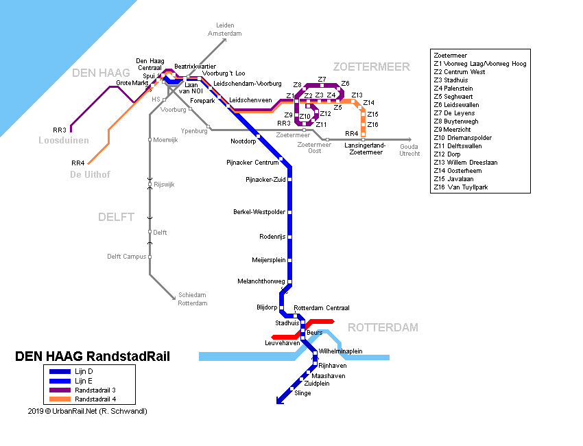
Jan summarized the Randstad Rail system map and how it influenced the planning.  I haven't actually used the tram during my time in Delft. I have used the bus, but not the tram. The map of the Delft Line 19 that is being expanded to the TU Delft campus.

Enough summarizing the presentation. It's now time for the tour of the community!


Monday, July 2, 2012

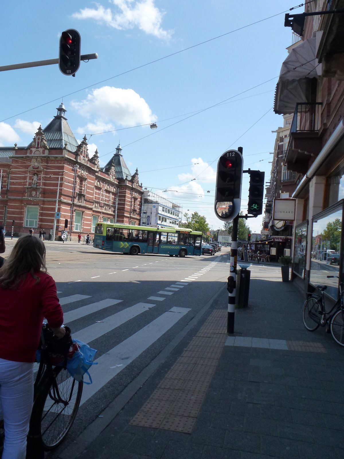
Dutch Bicycle Signal with Through Arrow - Clarifying Intent of Traffic Control - Den Haag, Netherlands

 In discussing bicycle signals with fellow transportation engineers, I am consistently asked what the green indication is intended to mean to a person on a bicycle. I am perplexed at this question because I believe that one could ask the same question for a circular green indication that is used for all traffic. With a circular green, it does not mean you should turn left (in your motor vehicle) from the right most lane of traffic.

That was exactly what a recent discussion inquired about. I hadn't ever considered whether a bicycle signal indication would given a person on a bicycle the clue that they could turn left from the bicycle lane across vehicular through lanes, essentially stopping all traffic in favor of the traffic in the bicycle lane. In our nine bicycle traffic signals in Portland, only a few of them are for the bicycle lane where there would be an opportunity to make a left turn across several lanes of through traffic, but I don't think that's a logical conclusion for a cyclist to make when there are other adjacent traffic signal displays or through arrows in adjacent lanes.

The pictures in this post show an example in Den Haag where some clarification was deemed necessary of the intent of the traffic signal and there was a need to provide clarity related to the bicycle signal was intended to control through traffic (note the small through arrow in the larger signal head at left. As you can see in the photo, the red pavement curves to the right, but this traffic signal is intended to control the through movement.  
Posted by Picasa

Thursday, July 14, 2011

PSU Delft Experience highlights

Taking the students on this adventure was a great experience. The program achieved its objective of presenting an introduction into transportation engineering applications in the European context. It built on earlier courses with a special emphasis on differences between U.S. and Dutch standards. The course curriculum featured material that shows the contrast between engineering principles and policies focusing on the standards presented in both the Manual of Uniform Traffic Control Devices and the Highway Capacity Manual. More on the PSU website:

The last full day in Delft is marked with heavy rains and wind that will soak cyclists to the core on even the shortest trips. The woman helping me check out of the place I was staying chalked it up to climate change. Climate change is a serious issue for the Dutch considering that a good percentage of them live below sea level. It's going to rain 55 mm today, just over 2 inches.

I am pleased with the rain because it is giving me a chance to catch up on the students' projects and blog posts.

So here's my Top 5 things that happened on the trip (not in rank order, sorry Brian).

1. Jane Jacobs and her Influence - How European Cities Have Social Networks (no not Facebook)
My favorite post to date was a psuedo assignment related to the book I assigned for the class: Death and Life of American Cities by Jane Jacobs. Brian Davis provided this insightful blast related to how communities can be organized to provide social support. It's not something I ever learned in a transportation engineering course, but creating a transportation system that allows a place to play seems as important as any effort I would produce in my profession. Recognizing the importance of a local community is key to the success of city planning. The density of the City allows this easily in Delft, but I wonder if the combination of the Farmers Market, local businesses, and interactions surrounding Llewllyn Elementary will contribute to the sort of community that will make Sellwood like this.

2. Education of the Future Users of the Transportation System
I really enjoyed the lectures that were part of the program. I learned a lot that I am looking forward to taking back to the City of Portland to apply in our community. One of the most important elements in the Netherlands is their education of future users of the transportation system. It is mandatory that each student take a test on navigating the City by bicycle in the 7th grade. This is all part of the sustainable safety program. They get police involved during the test and the students go through a course that is on city streets. This is after a detailed program on an off-street course.

3. It's All About the Bike (in Urban Planning)

It's often debated of whether there is a bike culture here. I would argue there is, yet it is not a subculture. Everyone has a bicycle. Most use it on occasion which results in them appreciating the vulnerability you feel when one is cycling. This results in a fairly courteous driving population overall and everyone concerned with the safety of each other. They also appreciate the importance of mobility, so the streets carefully discriminate between those that are for cars and freight and ones that are community oriented. They have support for the bike oriented streets because most people cycle. The City of Houten was an extreme example for making it irresistible to cycle to most destinations as highlighted in Sam's post on the community. Kirk and Pam from the class have also done an amazing report that shows some of the bike vs. car routing. Kirk summarized his visit with some more pictures. We also saw the ring road that seemed to work really well for freight and other traffic movements that were longer than just a few miles.

4. What's Wrong with the U.S. - Getting the Little Things Right

I borrowed the last part of the title from Marc Schlossberg Most of the concepts common in the Netherlands are considered radical in the U.S. It seems that working with some of the principles will take time but that incorporating small items like bicycle signal heads that are 10 cm are worth moving the industry towards design at a human scale. It is also clear from this trip that many of the things I have been introducing at the City are consistent with practice here. It is very interesting to consider how the public and the press will take to these ideas. The Portland Mercury followed some of the work here, but they are also the newspaper that post the Pedalpalooza schedule (not exactly on the coffee table of every home in Portland).


Traffic Signal Timing for Cyclists from Peter Koonce on Vimeo.


Here's another one that we did for Broadway/Williams. This is important for the Broadway bicycle traffic that we're trying to make safer. There's a slight tradeoff currently for motorist traffic that we will improve when we make the modification at Victoria associated with the streetcar.

5. Creating the Transportation Leaders of the Future

Lastly, I had a great time getting to know the students of PSU, Peter Furth, and Tom Bertulis. Their energy and excitement about the future of transportation was an inspiration during the trip.

So, in all a great experience. Now, it will be great if it will just stop raining.

Leaving Delft

Luckily I won't feel like Yehuda does in this comic when I get back home.


Unfortunately, this is reality in many U.S. cities. There's a lot to be said about safety in numbers and Portland has been successful in doing a lot with a little. I am looking forward to the future. I pondered my return to Delft and after finishing dinner, biked through the amazing square paying respects to the people of Delft that built such amazing monuments. 

Wednesday, July 13, 2011

Rotterdam Part 2

Entering the Maas Tunnel, we enjoyed the elevator that took us down below the river. Kirk Paulsen, Tom Bertulis, Kate Petak, and several Northeastern University students (in the background) were amazed by the infrastructure and the 1,070 meter length of the tunnel.
As I was taking this picture, I was thinking "Welcome to Rotterdam, now get underground".
For the next picture it was, " Welcome to Rotterdam, there's traffic behind you!"  Rotterdam is a bustling metropolis, very busy with traffic and freight as it hosts the second busiest port in the world. Not known for its cycling infrastructure there are parts of the City where you feel like you're in the U.S.


One of the most impressive sites in Rotterdam outside of the wide range of modernist architecture and buildings is the Erasumus Bridge. This engineering marvel was completed in 1996. The 802 metre long bridge has a 139 metre-high asymmetrical pylon, earning the bridge its nickname of "The Swan".
Posted by Picasa

Tuesday, July 12, 2011

Portland State Student Blogs for the Study Abroad Course

Updated to bring this to the front of the page. I continue to use this to keep track of the students and their work. I am expecting the students on the Portland State University Study Abroad course to produce all of their information electronically via their blog. We have a number of assignements prepared. Here's the list of blogs.

Brian: http://halfthefun.net/
Will: http://wrfarley.blogspot.com/
Pam: http://eurobikegeek.blogspot.com/

Sam: http://smonsef.blogspot.com/
Kirk: http://www.pedalportland.org/blog/
Kate: http://katepetak.wordpress.com/
Ian: http://eotrout.blogspot.com/

We're not the only Oregonians in the Netherlands studying this summer. Marc Scholossberg has a group of students from the University of Oregon and Portland State. Their blogs are online at: http://2011bikesabroad.blogspot.com/

Thursday, July 7, 2011

Houten - PSU Delft Day 4


A fantastic day in Houten. The town of Houten has some fascinating urban design characteristics. This is especially true for how suburban the community is being outside of Utrecht a few train stops. The town of about 50,000 has two key features. First, a ring road that serves car access. This is virtually a ring road that allows access to about 300 to 400 different homes. These are mostly via traffic signals, but there are some that are unsignalized. The second element that is remarkable are the bicycle highways that they provide through the center of the city. The north portion of the City is bisected by a 3.2 km bike highway that results in the neighborhoods having amazing bicycle accessibility to all of the other neighborhoods. The streets do not allow auto access between neighborhoods, which is the function of the ring road.
The approaches to the bicycle highway are shown in these pictures. There are yield signs for traffic. The other unique element within Houten is that all of the reisdential streets are 30 km/hr speed limits and the fietsstraat signs share the message that cars are invited to stay behind the cyclists on the streets and prioritize their fellow residents.
Peter Furth calls it a "bicycle heaven" within the Netherlands which itself is bicycle heaven. There are a few things the class can learn from Houten, but being that it is a suburb, the model might be best applied on the outskirts of Portland as opposed to most of our city where we can wall off our residents from cut through traffic.

One of the concepts we learned from the Dutch is the concept of roadway demotion. Let's say the ring road needs to be expanded to add more houses. In this case, the old road that was the ring road will be usurped by a new road that widens the scope of the City. Once that road is complete, the old street can and should be used differently. Thus, you demote the old road from a 70 km/hour design to a 50 km/hour. In Houten, they made a bicycle roundabout grade separated from a roundabout that controlled the access to the office/work space.

Posted by Picasa

Sunday, July 3, 2011

Ikea just like any other

One of the primary reasons to travel is to have new experiences. We're staying next to an Ikea and it makes me reflect back on the one trip I made while working as a consultant for Costco. The trip was back in 2004 or so and I was travelling to Mexico City to review several Costco sites, specifically to identify traffic signal "improvements" or widening actions that were being requested by the local agencies. Most of the recommendations were based on standard American engineering practices, which is to estimate the number of new vehicle trips, assuming worst case conditions and unlimited supply of vehicle parking spaces, traffic capacity for the surrounding street system, and a booming economy. The last issue identified there doesn't fit, but the first two are totally within the local jurisdictions control.

I remember being in the Costco in Mexico City and recognizing everything. The cash register layout, the shelfing, the advertisements as you leave the facility. It was like a little slice of suburban America was shipped south and translated into the Spanish language.

A little more on the experience at the Family Blog.

Posted by Picasa

Leading Bicycle Interval

We arrived in Amsterdam and the first thing I did upon arriving is visit the closest traffic signal to our hotel. I was interested to compare the experiences in Denmark with the Dutch practices. This was a minor street connecting with a more significant street adjacent to the Rijksmuseum. The first thing noticeable about this signal was that the indications for the bicycle are nearside. The second is that there are two separate indications (a large head mounted at around 3 meters) and a 10 cm (4 inches) indication. My guess is that the redundant signal head is used for the same reason we use multiple displays, but can't be sure. The third and most interesting from an operations perspective is the leading bicycle interval. I tried to take as many pictures as I could one after another to guess at how much time the intervals was for the bikes (it was about five seconds based on my camera time stamp). It seems that the reason for a Leading Bicycle Interval (LBI) is that the crosswalk is very large and it would be a nice thing to allow people on bicycles to establish themselves in the intersection across the crosswalk and to make the turn if they were so inclined. This might reduce the potential conflict point at the intersections which you can see just past the crosswalk and out of the shade of the curb tight building. The fourth application which we have used very sparingly in the U.S. is mirrors. In this application, I am guessing it helps freight and other motor vehicles determine if there are pedestrians coming up along the sidewalk and bikes approaching. It's another cue for encouraging the safe movement of traffic. I can already hear the complaints of maintenance staff if we proposed these at intersections.

Assuming that a community only wants to spend so much for a traffic signal (I doubt the Dutch love their signals any more than we do), in the U.S. (and in Portland), I would like to do an assessment of what elements of traffic signals cost us the most money (foundations for signal poles and the mast arm signal poles themselves) and what yields the highest safety benefits. There are distinct costs for traffic signals that require to be mounted over the lane lines and that is a function of the assumed speed of traffic and reaction times and so many human factors issues that it would be very helpful to know the tradeoffs between actually safety elements we design at intersections and their cost. I would be willing to wager a strong cup of coffee at Water Avenue that we could save ourselves a lot of money if we traded the costs of foundations and invested in better detection, marking on the pavement, and maintenance resources.
Posted by Picasa

Sunday, June 26, 2011

Left Turn Bicycle Signal in Copenhagen


There is clearly a social contract between engineers and the public that chooses to ride a bicycle through traffic signals that we design. As a designer, you try to make the indications as clear and unambiguous as possible and there is a certain amount of consideration for what the expectation is for a reasonable person to understand. I think this bicycle signal displays meets that criteria. The display is inline with the cyclist maneuver at the intersection. It is a delineated movement with striping on the pavement.

One might argue that it might be a little unclear at night, but I would take that arguement and in this instance it isn't reasonable to assume one should be able to make a left turn from the right lane. This sort of situation wouldn't preclude you from taking the lane and making the left turn, although it could be argued that the signal timing should be set up to insure that the arrivals of the motor vehicles occurred (faster speeds) followed by the bicycle traffic (from the upstream intersection).

I am blogging about bicycle traffic signals and I stop and wonder am I the only one that is thinking about this. Well, luckily I caught the following this evening from the Copenhagenize.com blog on traffic signals in Barcelona.
Posted by Picasa

Thursday, June 23, 2011

Transportation in Copenhagen


The blue marking denotes a conflict area for oncoming
traffic that is accepting a gap in vehicle and bicycle traffic.
There's clearly a commitment to human scale transportation in Copenhagen. There are several tradeoffs between vehicle travel and bike ped facilties shown in these pictures.
The striping of the blue bicycle lane and the crosswalk ladder striping show a commitment to maintenance that we don't make in the U.S. We have used green selectively to identify conflicts at intersections and while an oncoming permitted left turn across this blue is present at this intersection, we wouldn't use green striping here if we had a similar intersection in Portland. There's also not the expense of mast arm signal poles at these locations. They use predominantly post mounted signals at the intersections that require motorists to search for the indication in their field of vision. It is done at the risk of safety (our mindset in the U.S.) which in our practice places the traffic signal heads over each lane of traffic prominently displayed so as not to put any doubt as to who has the right of way. Does doubt and uncertainly result in lower speeds and ultimately a safer multimodal environment?

The signals at this particular location were manufactured by Swarco,
an Austrian firm that we are trying to procure bicycle signals from.

Posted by Picasa

Bicycle Traffic Signals in Copenhagen

A paradigm shift is necessary in the United States for traffic signals to effectively serve bicycles. Copenhagen serves as a model for us, yet it will require substantial changes in cyclist behavior in addition to the robust redesign of signalized intersections to accomplish a more sustainable model for moving the industry forward.
This particular example of a cyclist is at a location where the left turn demand is fairly light, but the cyclist in the picture exits the cycletrack on the right and knows to wait for the pedestrian crossing on the perpendicular movement in order to make the left turn. There is no special left turn indication for this movement at this location (largely because it seems like a low volume movement). It would be very nice to have traffic volumes and safety data for these intersections.

The GPS enabled camera that I am using geolocates my pictures in the ballpark.

The smaller four inch heads seems sufficient for the needs of slower moving vehicles (bicycles). The blue bicycle with white stencil seem to be clear and matches the blue pavement markings that the Danes are so used to seeing delineating where bikes are present. That is probably not a coincidence.

I tried to connect with an engineer from Copenhagen that was identified as part of the AASHTO European scanning tour, but did not hear anything back when I sent emails to the staff in Malmo or the staff in Copenhagen. It could be that my email was spammed or that our system blocked their message in return. Isn't it unfortunate that our email systems would keep us from communicating with one another.

The vendor of the signals that I have seen prominently on some of the signals is Swarco. They are based out of Austria and we have been trying to purchase a signal head from them for the past three months. Unfortunately, we're only asking for a half dozen or so, thus it has been hard to actually procure the equipment that we desire to initiate that paradigm shift. If we dud use the blue light special on top of the red, yellow, green display, should we use green on top instead of blue since FHWA required us to use green on the pavement (probably not a good idea because of the potential for confusion.
Posted by Picasa