Showing posts with label Dutch. Show all posts

Tuesday, July 10, 2012

Visiting Houten - Bicycle Heaven, "Fietsstad 2008" - presentation by Andre Botermans

Andre Botermans from Houten
Andre is a planner with the city and had a tough act to follow from last year when Herbert Tiemens, an Engineer gave us the presentation in 2011. He started with a history of the town and nearby Utrecht. In 1867, it was 1600 people. It had a rail station that was central that ultimately became central to its development. Nearly 100 years later, in 1950, it was the same size.

In 1966, the regional government decided to build houses in cities and it was declared that  the rural areas would stay free from urbanization. Houten was tabbed in the second round of growth to 100,000. Citizens fought back and the number was reduced to 30,000. Paper on Spatial Planning - Structuurschets 1e groeitaak

Example of a park along the Houten Bicycle Highway. 
The Dutch used "Rational" Urban Planning based on the small scale, conscious of nature and the environment. Andre indicated that it was developed in a time before sustainable development was a fully formed concept. The idea started with the idea of a Bicycle City, leading bicycle routes to the train station. Car infrastructure was set up as a ring road without connections internally between sections of the neighborhood were going to emphasize bike safety by reducing interactions with cars. Also, cars are asked to give way to bikes in all cases and separated at the ring road.


The primary schools are located near the Central Greenway so access for children is guaranteed.  Parks are located throughout the city and many are connected to the Greenway.

Bottle return by bicycle (he biked with two on
the rear rack and had two more 12 packs in his
panniers).
In Houten, "most of the things we do by bike". Everything is at such a short distance: shopping, school, parks, etc.
On the ring road, there are higher buildings to design as a gate to frame the entrances where you can go into the living area. The intent was to base the design like an old Roman town. These larger buildings on the Ring Road are often offices or else often used by elderly as they get a nice view of the countryside as apart of their location.

There are very few long roads, in fact the maximum tangent section used in planning is 250 feet. All of the bike routes are in red asphalt to communicate the intent of each facility.

They are planning a new roadway connection to A12 that will relieve some of the congestion to the main link to the freeway system.

Houten's bike safety record and crash rate is 31% of Dutch cities of comparable size because of the limited interactions necessary. When thinking about this, I think this is a result of a high percentage of families (it is a suburb) and the higher income and education level than comparable cities. Nationally, 49% of the houses are owner occupied. Houten is 70% owner occupied and the second phase will be 80%. There is a lot of discussion about this that could be called go question. Houten is a more expensive suburb than many surrounding communities. So to say that Houten's unique design makes a community 70% safer would be an overstatement, but Andre didn't make the case for that, he just stated what the results are.

Bicycle parking in the Houten train station. 3,000 spaces!
Bike parking is fantastic at the Central station, with over 3,000 spaces. It is massive and free. No subscription or annual cost for parking bikes. They have 200 bikes often left over night, but they don't worry too much about that as they can sign them as needed and pull them away.

There is security cameras for the facility and a bike shop so that you can get help if you need it. The OV Fiets rental is also there if you don't have a bike and need one for the day. A little more on the facility here.


Andre indicated that there are a lot of cars in Houten. A lot of the families have dual income with kids so they have the means to buy cars. Many of the jobs in the community are white collar. The city estimates that 1/3 of employment is in Houten, 1/3 is in Utrecht, 1/3 is elsewhere. Future growth will seek to have equal jobs and the number of people. Utrecht is a 12 minute train ride to downtown Utrecht. Jobs outside if the Utrecht Central are accessible by bike or by transit transfer.

A few other interesting facts worth sharing about the community:

Housing in Houten has some unique
features, including these that are right
on the water.

  • The City wants to be careful to implement jobs with their expansions with the intent to use this to reduce GHG. 
  • 23 houses per hectare us the approximate density of housing. New area is 24 per. About 10 per acre. Pijnacker (near Delft) is 34 or 15 per acre.
  • The City officials are going about retrofitting the old village circa 1950 to make it consistent with the current standards, but it is occurring slowly due to financial constraints.

The "second growing task from the National Government is issued in 1991 and again Houten was not willing to grow, but the compromise was to end up at 60,000. Andre described several concepts that were laid out. Ultimately, the planners focused a new town along the railway south of the existing part. The urban planner was Rob Derks, who is retired now, but still lives in Houten. The new area has no central greenway, but a five sided greenway that has a smaller center and the existing center is strengthened.

The new town center of Castellum included medium density
around the city's second train station.
The south section was chosen by the municipality, but the land was owned by speculators. Thus, the municipality had to partner with the developer and it took a long time to get to a solution that wasn't too dense for Houten's vision. The new site is called Castellum and that has also been planned around a new station. Houten's existing center is intended to grow and the new south center will be a minor station.

It seems like a pretty fantastic minor station that if we completed community planning as they do would be a vast improvement in the Portland metropolitan area, but of course the existing communities are not nearly as farm focused and the development of streets and all of the other infrastructure is much different than the U.S. experience.

UPDATE: Here's a Youtube video summarizing Houten.


Monday, July 9, 2012

Day 9 - Travelling to Houten

As we prepare to head out this morning, I reread the post by Brian Davis What Jane Jacobs Might Think of “Bike Heaven” « Half the Fun (± 49%) that reminded me of the uniqueness of Houten from an urban design perspective. I am looking forward to the trip and a visit to nearby Utrecht.
The train ride was extended by 30 minutes due to some construction on the tracks between Gouda and Wourden, so we had less time in Houten than they year before.
The presentation was summarized here BLOG Reference and after a brief lunch we prepared a map to highlight the key sites to see while in the community. Peter Furth summarzed the list of 19 things to see including the grade separated bike roundabout, the developments around the train stations (Castellum which is the new one and Centrum which is the Round), and many of the 15 undercrossings of the Ring Road (Rondweg).
The following website summarizes the 19 points of interest.

Here's a short summary of the design of Houten, circa 2003.

DAY 6 - Weekend Trip to Leiden

After a busy week it was time to relax a bit and enjoy a community or two that I hadn't explored before. Some of the students went for a weekend tour of Dusseldorf, others to Amsterdam, but Rob and I biked to nearby Leiden. Leiden is a college town that has the oldest institution in the Netherlands. The number of universities seems to be high per capita, but they aren't as large as ours in the U.S. One could argue that 40k plus students is not the most effective learning environment.

One subject of debate throughout the week is why and how the Dutch are so good at creating outdoor public spaces that work and are nice places to linger for a coffee or beer. The first and most important element of the best ones is that they are free from noisy traffic (autos or scooters). They offer opportunities to watch people go by. They are comfortable, qwe were in two  different ones yesterday that had outdor couches with umbrellas. The spaces they create are largely free from beggars and maybe thaf is a functiin of their excellent social services network (Rob said this isn't always his experience in Italy (as an example).

We discussed the area aroud Skidmore Fountain and the new Director's Park. The latter is truly a great place because it offers an attraction (water feature), a place to sit (under the glass canopy), restaurants and cafes, and is close to the main shopping district.

One thing the Dutch don't beat us on is coffee, ours is superior by far.

Traffic Signal Phasing Design - Dutch Practice

Today, after the student lecture I sat down with Theo Muller who is one of the most brilliant minds in traffic signal control in the Netherlands. He provided training on VRIGen which is a program used to develop signal timing phasing plans given the complexity of the movements for the multimodal system that is common with buses, trams, bikes, and pedestrians at so many intersections.
Signal Phasing Diagram (assuming a median) 


Incorporation of bikes, trams are something the Dutch have done because of the challenges or complexities these modes have presented as a part of large projects. The signal phasing numbering scheme is set up in VRIGen and it is used throughout the country to standardize and allow them to deal with all (most) possible options. It seems they have used every number from 1 to 100 to make the various modes work together under a standard umbrella.
Signal Phasing assuming Transit in the Median
Note: transit can turn from each direction and bikes wither would
be handled different than shown.


How is this different than the U.S.?
In the U.S., we have 8 vehicle phases, multiple overlaps, and pedestrian movements tied to the parallel vehicle and LRT is handled as a preempt as opposed to another movement. The standard signal controller is not prepared for light rail or bus crossings in both directions (east-west & north-south) running on the median. The Dutch also assume the special considerations of the use of multiple numbers to allow 2 stage crossings as a part of the bikes & peds because of their slower speeds. This also allows "following" phases to occur for vehicles so progression can be achieved through an interchange or a set of two signals, like you might have at a diamond interchange.


What common guidelines do they apply that the U.S. should adopt?
The maximum cycle length is a good place to start. 120 seconds is an eternity for peds and bikes and that value and higher is to going to result in poor compliance and high delays for public transport
Another common approach is to use snappy detector timing. The use of 1.5 seconds of extension from the upstream (advance) detector is limited to the detector placed 30 meters from the stop bar with a detector that is 12m long. They use a 2.5 gap on the stop bar detector with a 2.5 second extensin with presence mode enabled, meaning that when a vehicle is present on the detector it continues to ask for more green.
We discussed the use of leading pedestrian (or bike) intervals (LBI or LPI) and it was surprising to hear they use 2 secs. They use LBIs when there is no right turn lane exclusive for controlling the traffic separately in two separate "streams" which is much preferred in the Netherlands for safe operations that remain efficient. Notice I stated safety was first, Theo indicated that more than half of all signals are there for insuring safe conditions for all users. Our MUTCD is a far cry from that without the proper use of engineering judgement and a strong protection of future multimodal traffic growth.

What are the downsides of this approach?
There were a few things I would like to discuss more with a practicing Dutch traffic engineer. The common practice is to separate out the right turns. This clearly results in a different set of conflicts as shown here:
The bike movement is labelled 21 (on the left in the red brick area) and the right turn is labelled 6 in the graphic (to the left of the car you can see the right turn arrow). 
This sort of configuration represents a reduction in vehicular capacity if there is a heavy right turning traffic and the photo shows a shared left turning and through movement which results in some complications potentially. There is clearly an emphasis of bicycle movements at the intersections and in the photo you can see the pedestrian is not striped through the cycletrack. It is assumed that it is no problem for the people on bicycles to sort themselves out with pedestrians and it is clear to pedestrians that they aren't supposed to be in the cycletrack.

Sunday, July 8, 2012

PSU DELFT DAY 5 - Energy Production in the Greenhouses - The Netherlands

Our students enjoyed Friday's trip to the North Sea and the beach. There was a bit of mist in the morning, but by the time we got to Monster (that is the actual name of the place) it was warm and playing on the beach was a nice reward for cycling the 18 miles through the cities and towns between Delft and the sea. It was quite a bit different for me than last year because the kids weren't with us on the ride. We had great weather (we couldnt say that last year) and the visit to the Greenhouse was enjoyable.

A few takeaways from the Greenhouse:

In the winter months they do quite a bit of warming, so energy consumption was a cost of doing business
Burning kerosene was the old way and plants that were near the burner grew faster (due to CO2
Now that CO2 is piped in to increase production, plants eat it up!
Tiny roots are still started by hand (mechanical processes have been developed in the past three years but the costs of the equipment are very high)
There are royalties for the creation of plant species of $0.06 cents (is that Euros?)
The greenhouse produces 3 million plants a year
The plants are now designed to be ready in les than 8 weeks (7 plantings a year)

Greenhouses in the Electricity Production Role
The greenhouse makes as much money on power generation (depending on prices and peak demands) as they do on their original core business.
The Dutch energy system is more robust because of all these local farmers burning CNG to provide power or using thermal sources. We asked about brown outs and they sort of shrugged it off as something they are unfamiliar with.

The biggest takeaways for me was the power production that they are involved in. A fascinating development and diversification of their business

Future considerations could be whether they will incorporate solar (they obviously use it naturally in the greenhouse) and storing energy in battery systems to address peak demands.

They do a bit of shipping from the facility and they have rucks thaf do this. Taking a look at the vehicles I noticed they have guards on the wheels to reduce the likelihood of cyclists getting pulled under a wheel.

Saturday, July 7, 2012

Bicycle Highway in South Delft adjacent to N470

There may be no better way to encourage people to use bicycles for transportation than providing separate facilities, completely free from the risk of injury. This sort of commitment would take a significant amount of effort and lucky for me in my job, we aren't quite ready to invest in that level of infrastructure for cycling in all cases. The Dutch have balanced the scales to make that commitment and the Bicycle Highways are the epitomy of this. 
     The bicycle highways (overcrossings and grade separations of paths) in the Netherlands are another . The cycletrack is all at grade with concrete separation (islands defined by curbs) defining the edges of the travelways. The red coloring indicates the cycling facilties and there is some wearing away of the markings associated with the heavy traffic movements that are occurring at this location (pictures were taken late in the evening).  This bicycle interchange near the TU Delft campus is at N470 and Schieweg. The interchange is grade separated from the N470 and for the parallel bicycle facility that connects the southern part of Delft with the Delft Zuid (South) train station.     
The bicycle signals are essentially two stage crossings for bicycle movements, carefully coordinated to reduce delay for motor vehicles and separated from pedestrians in order to keep the signal timing snappy.


The turning movements for cyclists seem fairly small and during busy periods I am unclear how they keep the main cyclepaths clear for through traffic.

The following video provides the perspective of a person on a bike approach from the west and accessing the Schieweg, the north-south street that crosses under the bike highway and the N470.


Posted by Picasa

Thursday, July 5, 2012

Day 4 - Tour of Rijswijk and Den Haag and Discussion on Designing Multimodal Intersections - Day 4

Tour of Rijswijk and Den Haag

On the fourth day we had a tour of the suburb between Delft and The Hague, which is Rijswijk. Paul Wiggenraad, our host from TU Delft, is a resident of 25 years, so he has seen much change in traffic safety that he could share with the students. We had several stops along the way including the Den Haag train station. The Hague has two main stations, HS and Central (former SS), originating from two railway companies Hollandse Spoor (spoor is Dutch for railway) and Staatspoor (private company operating the lines built by the state). In 1938, these two merged in the Dutch National Railway systems. HS is a station on the Old Line (Amsterdam-Haarlem-Leiden-Den Haag-Delft-Rotterdeam) and SS is the terminal of the Utrecht-The Hague Line. 

The new entrance to the Den Haag HS station is modern. 

During the rebuild of the station, they added some fantastic
 bicycle tunnels underneath the old tracks. Pedestrians have similar access.

The station building dates from 1893 and is built in the classic Dutch style.
Obviously, much different than the backside of the building. Trams cross in front of
the station here and create a busy street that is a bit daunting to the first time visitor.

Along the Tour we stopped at a bicycle box that was used along the canal.
The vehicular travel lane is 7 feet wide, the bike lane is 4 feet and the opposing travel lane is 7 feet.
On-street parking is 6 feet and it was evident by all of the vehicles tight against the curb
and with their wheels (the larger ones at least) on the stripe to indicate parking.

We ended up on several bicycle highways, this particular overcrossing gave us
 a nice view of the cycletrack on the right hand side of the street, complete with the
separated right turn lane (note the stop bar set back 50 meters or more. The intent of
the setback is to limit the ability to make right turn on red and to improve visibility.
This sort of treatment has to reduce vehicluar capacity considerably.
It is worth nothing that the off-ramp to on-ramp movement (through at the signal crossing, in
other words what would be moving from from left to right in this view) is not allowed.
That movement could physically happen, but it isn't specifically allowed.  

Critique of Current Manuals

Upon returning to Delft, we had to resolve an issue with a flat tire and then we had a lecture on what we've seen and how that might be incorporated into our cities. Peter provided a summary of some of these elements as well as some of the limitations of the following documents.
AASHTO Bike Guide
NACTO Urban Bikeway Design Guide
He then proceeded to show the video: Junction Design the Dutch Way, after which  he advocated for designs of this nature with the students. The compromise for pedestrians is of interest and should be carefully considered. This is a subject worthy of more debate.

Separation of Through Cyclists from Right turning Traffic 

Peter Furth indicated that the Dutch manuals suggest separation of the right turning traffic and the cyclist movement when the right turn is greater than 150 vehicles.


Wednesday, July 4, 2012

Haaglanden Regional Planning - Day 3

The speaker on Day 3 was Jan Termorshuizen from the Haaglanden who was has lectured to the class each year.
He described the overview of the region and what he's involved with. He highlighted the region's  Randstad Rail, cycling policy, physical planning and public transport, and Integral Planning.


An example of Integral Planning is the consideration that the Dutch must have for where water goes. Considering that much of the country is below sea level this is critical.

Population and Land Area - Details of the Hague

He described the Netherlands and compared it to the population and land area of Massachusettes, Conneticuit, & Rhode Island. From Wikipedia.

Area(2006)
 • City andmunicipality98.20 km2(37.92 sq mi)
 • Land82.66 km2(31.92 sq mi)
 • Water15.54 km2 (6.00 sq mi)
Population (1 February 2012)
 • City andmunicipality501,725
 • Density5,894/km2(15,270/sq mi)
 • Urban1,022,256
 • Metro1,406,000


He also indicated that there are 15.3 sq. km of Industrial estates and 35 sq km of greenhouses.

Regional Planning Over Time


The regional government is guided by the intent to "Do local what can be done local, Do regional what must be done regional", suggesting that there are some communities that aren't large enough to have the expertise to serve a community effectively. [My experience in private practice indicated that there was wide variety of expertise in government agencies of all sizes].

Jan described the history of planning based on his 30 years experience. In the 1970s and 1980s he indicated that the Dutch had a policy of "Bundled Deconcentration" with new light rail lines in Rotterdam, Den Haag, and Utrecht. There were more cars during this period and larger houses. They used selective urban renewal which included displacing people.

In the 1990s there was a shift to build at the edge of the cities and extend urban railways systems. There was quite a bit of effort to complete traffic demand management measures. People didn't like the demand management portion, so when there was success there was a change in how the policy was communicated.  Jan introduced the ABC land use zoning with A being the type of office that you can easily serve with transit and C being auto focused development. They began using their ABC location policy of offices being very important to be near rail stations and recognizing that not all development needs to be well served by rail or public transport and finding success. They have been very good in recognizing the importance of this and integrating bicycle use throughout all different types.

In the 3rd Millenium, he characterized the lack of money for investment and public transport operations. There is a more business like approach of public transport and reuse of existing

Their goals is to include 60-80% of new housing within close proximity of high quality transit lines. An example of this is that the new Delft rail station will be 1,500 housing units and a City building integrated there as well.

History of Community Planning in the Haaglanden

Pijnacker in 1950 was a small community, "village" on the rail line between Den Haag and Rotterdam. Nootdorp was off the rail line but in between Den Haag and Pijnacker.

Zoetermeer was a new town in 1965 when there was recognition of the need for more housing and became a much larger urban area. The planners focused a significant energy around that area and there were several areas to the southwest of Den Haag and Tanthof.

He indicated that it was not a good development because there were limited jobs in Zoetermeer, so people had to travel. It was also too far away to make cycling a reality (Dutch range of cyclists is 12 km away), and few people are biking to their jobs. Zoetemeer is off the major rail line between Den Haag and Rotterdam, so it only has a rail connection (spur line) to the central city and the frequency was not high enough because there were not enough people at the Den Haag Central Station to make it attractive.

The central city of Zoetemeer also suffered from lower densities than most of the communities. Most of the development were 2 stories. There were a few 20-story buildings, but they weren't very popular.

Ypenburg was built in 1995 and was a former Air Force Base. The community included an expansion of the existing tram system into the system and there was also a new railway station on line between Utrecht and Den Haag. Being on the major rail station gives Ypenburg a distinct transportation advantage (for serving non-auto trips). It is also only 5km from The Hague, so cycling is an option for more of its residents in getting to work.

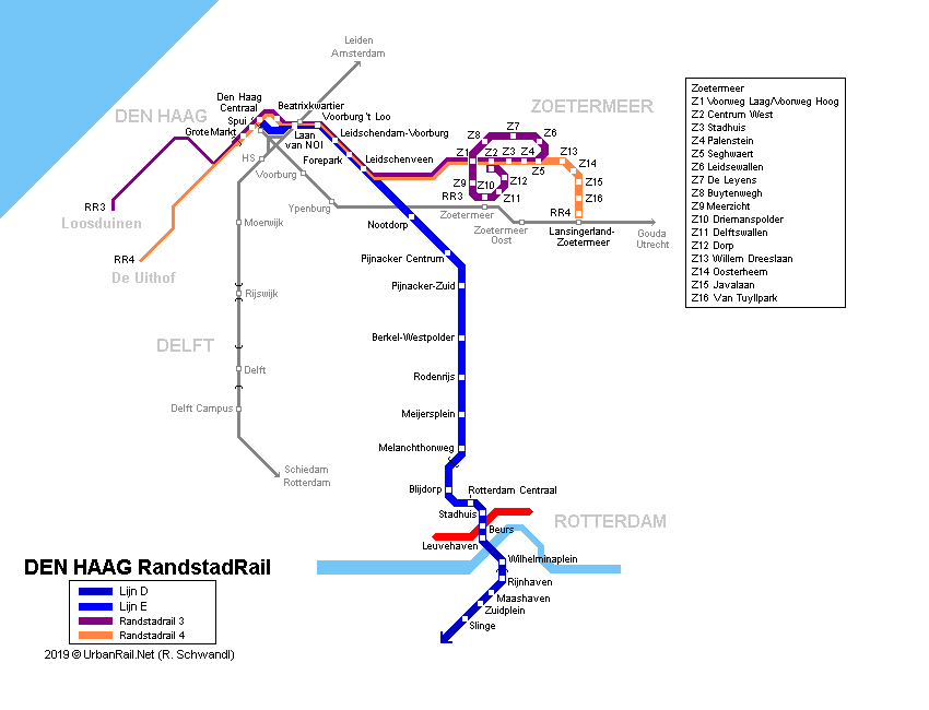
Future plans from Zoetermeer is to reconstruct the heavy rail line to be part of Ranstad Rail so that there is more local service and it is a more comprehensive system. The smaller vehicles offer cheaper service and there can be higher frequencies. The light rail trains have better accel and decel properties, so overall Jan felt it was a higher quality of service for accessibility.

Future of Planning and Public Transport

There's a recognition of some of the missteps from the past and energy is being focused on using operations at stations along public transport lines. There interest currently in developing along exsting railways and trying to avoid office developments in decentralized locations.

Peter Furth indicated that in Boston, the suburban communities are fighting for office space because they pay additional taxes than residential property and they don't send children to schools (which the locals have to pay for as well). The Hague doesn't seem to have any issues that are similar to this.

Jan described the current focus on Integrating Public Transport into community. There are 8 principles:


All areas have a direct PT link with city center and one of two main railway stations
All stations have one or more light rail with stops near the main entrance.
All homes have a PT stop at a maximum distance of 500m
Trams have high frequencies, so transfer is no problem
All railway stations and many tram stops have bicycle parking facilities.
Many railway stations have park and ride facilties
Bicycles in trams are not permitted, in light rail only after 7:00 PM and in weekends
Popular OVfiets (PT bike) system: www.ov-fiets.nl will be integrated at each station.


Jan summarized the Randstad Rail system map and how it influenced the planning.  I haven't actually used the tram during my time in Delft. I have used the bus, but not the tram. The map of the Delft Line 19 that is being expanded to the TU Delft campus.

Enough summarizing the presentation. It's now time for the tour of the community!


Monday, July 2, 2012

Dutch Bicycle Signal with Through Arrow - Clarifying Intent of Traffic Control - Den Haag, Netherlands

 In discussing bicycle signals with fellow transportation engineers, I am consistently asked what the green indication is intended to mean to a person on a bicycle. I am perplexed at this question because I believe that one could ask the same question for a circular green indication that is used for all traffic. With a circular green, it does not mean you should turn left (in your motor vehicle) from the right most lane of traffic.

That was exactly what a recent discussion inquired about. I hadn't ever considered whether a bicycle signal indication would given a person on a bicycle the clue that they could turn left from the bicycle lane across vehicular through lanes, essentially stopping all traffic in favor of the traffic in the bicycle lane. In our nine bicycle traffic signals in Portland, only a few of them are for the bicycle lane where there would be an opportunity to make a left turn across several lanes of through traffic, but I don't think that's a logical conclusion for a cyclist to make when there are other adjacent traffic signal displays or through arrows in adjacent lanes.

The pictures in this post show an example in Den Haag where some clarification was deemed necessary of the intent of the traffic signal and there was a need to provide clarity related to the bicycle signal was intended to control through traffic (note the small through arrow in the larger signal head at left. As you can see in the photo, the red pavement curves to the right, but this traffic signal is intended to control the through movement.  
Posted by Picasa

Sunday, July 1, 2012

Bike Overcrossings in Rotterdam - Complete with Supersized Escalators


Our leisurely Sunday bike ride provided us some further insights on the lengths the Dutch will go to provide an efficient and effective connection for people on bicycles. We decided to travel south through Rotterdam to evaluate some of the treatments in and around the third largest freight port in the world.  We turned up some very nice infrastructure without really looking for it. This and the Benelux tunnel post shows what sorts of accommodation is built alongside major highway upgrades.

This portion of the ride was the south most part of our effort.

This particular facility (shown in the pictures) was built alongside the A4 & A15 freeway to freeway interchange at the intersection of Vondelingenweg and Oud Pernisseweg. The facility provides access to Pernisserpark which is a nice outdoor space next to two very busy freeway facilities in a heavy industrialized area. We were there Sunday and the traffic was constantly buzzing on the freeways with a good amount of noise, so I can imagine it is louder during the week.


The screen capture shows the GPS track that was part
of the overcrossing of the rail tracks.
The overcrossing is in the southern portion of Rotterdam in the area called Hoogvliet and continues into Schiedam to the north. The short back tracking from the north to the south resulted in backtracking to take pictures of the highway A 15 below. The tracks match closely to our use of the ramp down in the northbound direction. 


A view from the top of the structure looking back at the separation.
Rail on the left and the "elevated right turn" we just made.
The cover for the escalator reminded me of the
sand crawler vehicle the Jawas used in Star Wars. 


This is the entrance to an escalator that allows people on bicycles to make a right turn over several freight railroad tracks. Obviously, it wouldn't be desirable for a cyclist to cross the heavy rail at grade, so this escalator is a facility that gets people up to the grade where they can crossover without any conflict. It uses the old road right of way ( I am assuming) that was vacated after the A4 highway was built.  Similar to the Benelux tunnel, one could argue whether this sort of facility (I almost called it an amenity) is necessary. There are many examples of interchange ramps where there isn't special provision for cyclists of this magnitude that work just fine. I will be interested in exploring this with the guest speakers we have and I am hoping there is someone that might discuss the specifics of this type of investment.   
Posted by Picasa

Tuesday, February 28, 2012

Information Session on Transportation Applications in the Netherlands - March 5, 5 PM - Study Abroad this Summer in Delft!

We'll be hosting an information sharing session on the program, next Monday, March 5th at 5 to 6 PM. The purpose of the meeting is to describe the details of the course. In order to do this we'll start off with a brief presentation by your instructors followed by a short summary of actual students who attended the course and lived to tell about it. Kirk Paulsen and Brian Davis will share their experiences of spending time in Amsterdam, while based in Delft all the while touring the nearby suburbs of Delft and communities (such as Rotterdam) that present an introduction to the multimodal transportation applications in the Netherlands.

A few questions I have received:
1. Do I have to be an engineer to participate?
Absolutely not. While the 7 students that participated last year were, their knowledge of thermodynamics and structural analysis did not provide them keener insights on the transportation elements common in Dutch communities. Working in teams as we did last year, any engineering skills you might need will be part of your group projects. 

2.  The course mentions efforts in Portland after the in country period, is that flexible?
Yes. The number of credits dictates the extent of the effort required for class projects. Last year, some of the students chose to finish the project before they left for the U.S. Others wanted more time to edit their class projects 
Here's a sample of some of the work that was completed. Brian's post summarizing his experience in "Bike Heaven" the community of Houten. The post actually was commented on by our host in Houten, community engineer Herbert Tiemens. Here's Kirk Paulsen's group's final project analyzing Houten as a community. 

3. Is financial aid available for this? 
Yes.  Financial aid is available for the program. The course costs are fairly reasonable compared to typical tuition and by taking the 6 credit option or an additional summer class you can easily be full time. Depending on your situation, I would encourage looking into this. The course doesn't have the overhead that normal classes do and the University wants the exposure for its students. The costs of housing are part of the program and staying in a dorm is an inexpensive place to stay relatively speaking. We complete all of our travel via bicycle and short train trips, so the biggest cost is the airfare.

4. Do I need to speak Dutch to take part in the trip?
No. I have been to the Netherlands five times and I don't speak a word of the language. 

5. Is it true that they don't have stop signs anywhere in the country?
No, I found three stop signs during my extensive travels, but it does take a couple of minutes to get used to. 

6. How do you deal with Post Travel and Carfree Bliss Disorder? 
I think Brian Davis covered this best in his blog post here, but Sunday Parkways is a good place to start.

7. Is this all about bikes?
No, but bicycles are a part of the Dutch culture and with a 30+% mode split for people travelling by bike, it is hard to avoid. Freight and transit will be part of the program as well and there's interest in having a conversation with the Utrecht Traffic Engineer Ronald Tamse who visited Portland and presented at PSU this past October. We define group project subjects that fit into the curriculum. Here's the final report that was a joint effort of Northeastern University and Portland State participants from last year. 

The session will be in the Engineering Building in the ITS Lab which is in Room 315. 
If you have any questions, feel free to send Dr. Bertini or I an email at your convenience. Looking forward to seeing some of you on Monday. 

The second annual summer course on multimodal transportation in the Netherlands:


http://oia.pdx.edu/ea/details/transportation_engineering_applications_in_netherlands/

Sunday, February 5, 2012

The Portland UGB Trail: A Concept for Building the Region's Bike Network

A regional trail outside of Delft features excellent wayfinding.
I have often said that there is a lot that we can learn from the Dutch. The fact that they have 35% of their trips made by the bicycle is by design, not an accident. I spent the last summer learning with the PSU students about this when we explored the seven communities throughout the 2-week program. There was a lot about land use planning and facility construction that were part of our daily field trips that I am sure I never captured via my blog. This foundation of knowledge is serving me well as I think about the future of the Portland region's trail network.

On a bike ride this afternoon, I found the Gresham-Fairview Trail. I have passed the spot on the Springwater several times, but never explored the link it makes north to Fairview. I recall biking on the Springwater a year or so ago and someone from the City was doing a study of the corridor and a survey of the potential users. Apparently, the trail was opened last year with Blumenauer cutting the ribbon. At the time, when I rode past the surveyor they hadn't yet finished the bridge that would connect the Springwater to the new portions of the trail (the following link has a summary of the project in a text box next to a larger story about Gresham and wayfinding signs). The survey was mostly about use of the Springwater and origin-destinations of users of the Trail. I wasn't aware of the context the time. I must have missed the BikePortland coverage that can be found here.

The trail is a wonderful connection in East Portland. It connects several neighborhoods and is a major spine for the off-street network. The trail may be underused (compared to the Springwater), and it is something that seems easy to overlook because it is managed by the City of Gresham. This is something that Metro's Intertwine could help with, but I digress. It is in a great spot parallel to the I-205 path. The trail doesn't seem to have a good north end connection yet. That will come in Sections D & E as described in the Trail Master Plan.  It may sound like a complaint but often our projects only go so far and there's no common way to designate the end of a trail or a transition from the higher order facility to a shared experience. I found a Ride Report from the Tandem club that similarly critiqued the signage at the  northern end of the trail (I wasn't clear I was at the end) and the crossing of the light rail tracks (I actually got off the trail due to a missed sign) .

So the operative question is how do we build more of these sorts of facilities. It looked like they cobbled together federal, state, and City sources over ten years to get this done. The good news is Metro is active in this and have great staff working on the effort. There are a lot of good projects that have been completed, and the 40-mile loop is one of my favorites.

There's a host of complaints one could make about this. The most important one is why does it take so long? The easy answer, and this is largely speculation, is that we don't own the land, money is scarce (we've spent the bond money on larger natural areas as opposed to trails), an no one is jumping to give us that land like in the Lake Oswego Streetcar case. For this reason, I would focus some of the efforts on communities that are not yet built up.

Outside Portland's Urban Growth Boundary (UGB), the land is undeveloped because our forefathers had the vision to use land use laws to limit sprawl and restrict their use. The concept, inspired by my bike ride, is this:

For lands outside the UGB, or on the boundary itself, the local jurisdiction and Metro should team up to buy right of way to create/preserve a trail facility that would further build the regional network. The land would either be donated by the property owners and valued at the urban price point (assuming it is exempted and brought into the UGB) or Metro could use its Regional Trails resources to purchase the land at 10% above rural prices to provide the landowner some relief to the costs associated with the land use laws.


What about essential nexus?
There is the Dolan vs. The City of Tigard case that put limits on what the public agency could require from a citizen or development, but it seems like this would eliminate that because the compensation would be part of my concept.

Regional trails can serve as linear parks.
The rural equivalent of Portland's Sunday Parkways!
In the Netherlands, there are a lot of great examples of this sort of trail development in the rural environment. I found in talking to folks that some of these are used for longer commutes. They are not all trails and some of them are cyclepaths or one way roads that allow for some passing by vehicles. These facilities stretch throughout the country and there are excellent maps to show you where you are and the direction you're headed.

The system was a little disorienting at first, but if you had a smart phone and a GPS the system would give you instant access outside of the urban area that we would get if we did something similar to my concept above.

Wednesday, December 28, 2011

Offering a New Transportation Engineering Perspective on Cycling Facilities: A Response to John Forester's Letter in ITE Journal

To the Editor:

In John Forester’s letter to the editor critiquing “Physically Separated Bikeways: A Game Changer for Bicycle Mode Split” (vol. 81, no. 4), he takes credit, as he has elsewhere[i], for alerting the engineering community to the supposed danger of bikeways that are physically separated from adjacent traffic. His objection is based primarily on his advocacy for a style of bicycling effective under what most people consider the worst of conditions: a roadway shared by bicycles and high volumes of fast motor vehicles. So-called “vehicular cycling”—essentially operating a bicycle as if it were a motor vehicle—allows the small minority of people willing to operate in such environments a safe way to ride. While Forester deserves credit for developing such a style, better alternatives are now and have long been available.


There is a growing consensus among transportation professionals and decision makers that direct their work that it is the diametrically opposite of Forester’s antiseparation doctrine that results in increasing numbers of people bicycling. Creating as much separation as possible between people riding bicycles from high volumes of motor vehicle traffic improves the safety and comfort of all road users. There is substantial and growing evidence to support these views based on the recent experiences with cycle tracks in Montreal, Canada, Portland, OR, New York, Long Beach, CA, and Washington, DC that are not merely anecdotal, but are being confirmed by emerging research. A 2010 study of Montreal’s bikeways found, not surprisingly, that they were significantly safer than riding in mixed traffic, as well as enormously popular[ii]. New York City reports similar results. Research suggests that the cycle tracks in Portland, OR increased cyclist perceptions of safety (particularly those of women)[iii], a necessary step toward expanding the use of bicycles across a broader cross-section of society. Of course, European cities have long known about these benefits of cycle tracks and comparative research has shown that European countries with cycle tracks had far lower bicycling fatality rates than America[iv].


Unfortunately, Forester’s statements reflect more a personal philosophy about the appropriate relationship of bicycling to driving than they do a reasoned understanding of current research and emerging trends. Stating that “[bicyclists] acting subservient to motorists” is an “indignity”, phrasing such as “cyclist-inferiority cycling” and discussion about how people riding bicycles are “disenfranchised” from riding on the public roadways by cycle tracks, are about as relevant to this discussion as is the 35-year old study Forester cites as the basis for his critique. He was also opposed to building rail-trails in the 1980s and 1990s for these same reasons, which have proven to be groundless.


The fact is that transportation policies are advancing to support increased bicycle transportation; a growing number of jurisdictions and the professionals that serve them are finding ways to accommodate that desired growth and are achieving success in doing so. With better alternatives now available, willingly planned for and successfully implemented in cities across the country, relying on vehicular cycling—and thus relegating bicycling to only those few willing to ride in such environments—would represent a failure both of policy and engineering. The growing movement to create cycle tracks in American cities is being facilitated by the engineering community’s recognition that separated bikeways can be safe, convenient, and attractive. The 2010 publication of the Bikeway Design Guide by the National Association of City Transportation Officials offers the first national guidance on separated bikeways such as cycle tracks. We hope that many other positive steps follow.

Signed,

Robert Burchfield, P.E., City Traffic Engineer, Portland, OR
Susan Clippinger, Director, Traffic, Parking and Transportation Department, City of Cambridge, MA
Michael Gardner-Sweeney, Traffic Engineer for the City of Boulder, CO
Brian Kemper, P.E., Acting City Traffic Engineer & Signal Operations Manager, Seattle Department of Transportation
Peter Koonce, P.E., Manager, Signals and Street Lighting Section, Bureau of Transportation, PortlandOR
Dennis Leach, Director of Transportation, Arlington County, VA
Andy Lutz, P.E., Chief Engineer, City of Indianapolis, IN
Susanne Rasmussen, Community Development Department, Environment and Transportation Planning Division, City of Cambridge, MA
Bridget Smith, P.E., Deputy Director, Livable Streets, San Francisco Municipal Transportation Agency
Wayne Wentz, P.E., Director Transportation Engineering, Arlington County, VA
John Yonan, P.E., Deputy Commissioner/Chief Engineer, Chicago Department of Transportation, Division of Engineering
Paul Zykofsky, AICP, Associate Director, Local Government Commission, Sacramento, CA
Mia Birk, President, Alta Planning + Design
John LaPlante, P.E., PTOE, Director of Traffic Engineering, T.Y. Lin International
Rock Miller, P.E., Principal, Stantec Consulting
David Parisi, P.E., Parisi & Associates
Jamie Parks, AICP, Kittelson & Associates
Todd A. Peterson, P.E., PTOE, Senior Transportation Engineer, Parsons Brinckerhoff
Matthew  Ridgway, AICP, PTP, Principal, Fehr & Peers
William Schultheiss, P.E., Senior Engineer, Toole Design Group
Andy Clarke, President, League of American Bicyclists
Dan Burden, Executive Director, Walkable and Livable Communities Institute
Keith Laughlin, President, Rails-to-Trails Conservancy
Barbara McCann, Executive Director, Complete Streets Coalition
Randy Neufeld, SRAM Cycling Fund
Gil Penalosa, MBA, Executive Director, 8-80s Cities
Jennifer Dill, Professor, Portland State University, Portland, OR
Peter Furth, Professor, Northeastern University
Ian Lockwood, P.E., Loeb Fellow, Harvard University
Chris Monsere, P.E. Professor, Portland State University, Portland, OR
John Pucher, Professor, Rutgers University
Roger Geller, Bicycle Coordinator, Portland, OR
Zaki Mustafa, Chief of Field Operations, City of Los Angeles, CA


[i] Forester, J., 2001. “The bikeway controversy.” Transportation Quarterly 55(2): 7-17.
[ii] Lusk, A.C., P.G. Furth, et al. 2011. “Risk of injury for bicycling on cycle tracks versus in the street.Injury Prevention 17: 131-135.
[iii] Monsere, C., N. McNeil, J. Dill. “Multi-User Perspectives on Separated, On-Street Bicycle Infrastructure” Paper 12-1753, Accepted for presentation at the 9th Annual Meeting of the Transportation Research Board, Washington, DC, 2012.

Friday, July 22, 2011

Green wave Raadhuisstraat - Amsterdam, The Netherlands

Great video describing a green wave for cyclists in Amsterdam.
Combined with the simulation it shows how people on bicycles can be given priority and how signal timing analysis and simulation can represent the real world.

Thursday, July 14, 2011

Leaving Delft

Luckily I won't feel like Yehuda does in this comic when I get back home.


Unfortunately, this is reality in many U.S. cities. There's a lot to be said about safety in numbers and Portland has been successful in doing a lot with a little. I am looking forward to the future. I pondered my return to Delft and after finishing dinner, biked through the amazing square paying respects to the people of Delft that built such amazing monuments.