Saturday, June 28, 2014

Bicycle Signals Recommended for Inclusion in next MUTCD

Bicycle signals have been used in many cities in the United States. Yet, many members of the National Committee on Uniform Traffic Control Devices have not seen these in practice because their agency is responsible for higher speed facilities or are from communities where bicycle transportation has not required their use. The same is a problem for adoption of bicycle boxes, contraflow lanes, and nearly everything that is included in the NACTO Urban Bikeway Design Guide.

Today, the National Committee voted to approve bicycle signals in the next edition of the Manual. This approval will amend the FHWA Interim Approval to permit a wider range of applications. The vote was unanimous and had limited discussion.
A bicycle standard mounted at typical heights at a signalized intersection.
A 4" nearside bicycle signal mounted
at eye level for a person on a bicycle.


Friday, June 27, 2014

Flexibility in Designing Bicycle Infrastructure

Buffered Bike Lane Exampl
Photo from San Francisco
The approach to street engineering design should be different depending on the context. One challenges of  uniformity is that it attempts to treat every street the same. As I have mentioned before, the speed of the street roughly determines whether the street is urban or rural in the MUTCD. Yet, these two examples for streets represent unique situations that present a unique situation not currently covered in the MUTCD. The double white lines shown at right means to the highway engineers that a person on a bicycle is not allowed to leave the facility and the vehicles are not allowed to cross. The use of the double white is currrently described for freeway applications, not currently used on urban streets.

The second example of a "new" type of facility for the MUTCD to consider is G Street NE from Washington, DC (provided by Bill Schultheiss of Toole Design Group). The challenge with this type of facility is that it presents a different interpretation of the use of double yellow lines than what's commonly used. The double yellow lines are intended to separate the directions of traffic and insure that the previously one way traffic is not in the path of the cyclist. The challenge with this sort of situation is the on-street parking on the right hand side of the picture. This raises concerns where high speeds on the facility exist. This sort of a facility is a low speed condition where the needs are quite different than in a rural condition. This is continued dialogue that needs broader consideration.   

The good news is that the FHWA is leading the charge to encourage flexibility in the design of pedestrian and bicycle facilities, citing both the NACTO Urban Bikeway Design Guide, the ITE Designing Walkable Urban Thoroughfares: A Context Sensitive Approach as examples of documents that provide useful treatments that can be applied to further walking and cycling in our communities.


Advisory Bike Lanes and the Request to Experiment in Minneapolis - APBP Sharing Information Successfully


Introducing new types of facilities to transportation infrastructure can be perceived as a daunting engineering challenge because of fears of liability associated with something that isn't uniform or standard. The MUTCD is often the first document that engineers go to when identifying what's possible. Adopting facilities from Europe or other parts of the world that aren't described in our typical references make a project difficult to imagine because there isn't experience with those types of facilities.

The Manual of Uniform Traffic Control Devices requires the use of a center line in the following cases:
Standard:
09 Center line markings shall be placed on all paved urban arterials and collectors that have a traveled way of 20 feet or more in width and an ADT of 6,000 vehicles per day or greater. Center line markings shall also be placed on all paved two-way streets or highways that have three or more lanes for moving motor vehicle traffic.
Guidance:
10 Center line markings should be placed on paved urban arterials and collectors that have a traveled way of 20 feet or more in width and an ADT of 4,000 vehicles per day or greater. Center line markings should also be placed on all rural arterials and collectors that have a traveled way of 18 feet or more in width and an ADT of 3,000 vehicles per day or greater. Center line markings should also be placed on other traveled ways where an engineering study indicates such a need.
11 Engineering judgment should be used in determining whether to place center line markings on traveled ways that are less than 16 feet wide because of the potential for traffic encroaching on the pavement edges, traffic being affected by parked vehicles, and traffic encroaching into the opposing traffic lane.
  
As a practitioner that traveled to The Netherlands several years ago, one of the treatments commonly used on Dutch streets is advisory bike lanes. The step that's necessary beyond "violating" the normal use of a centerline is to make the bike lanes striped (dashes as shown below) and in this case, the space for cars in between the dashed lines may be less than what's normally used for striped lanes in both directions. Thus, the width of that interior space is less than 20 feet and was measured to be as narrow as 16 feet with 5 foot bike lanes on both sides in the example here.
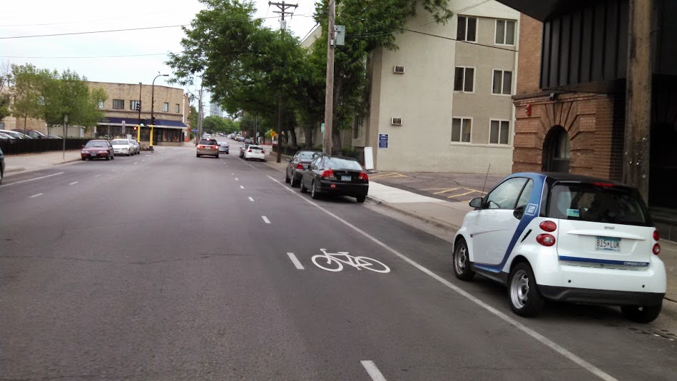
East 14th Street in Minneapolis has Advisory Bicycle Lanes

Minneapolis has implemented advisory bike lanes on East 14th Street. Riding on this street, I found it worked well (it was off-peak travel times) because of the low traffic volumes and low speeds. In our six block ride along the street, we never encountered cars passing each other at the same time, so when a motor vehicle did need to pass me, the person passed with a very comfortable amount of space (likely due to the elimination of the center line).

Advisory bike lanes or bike lanes without a centerline on a street (as shown at right) have been used sparingly in Portland. There has been some elimination of centerlines where the traffic volumes do not warrant the maintenance necessary to keep them marked. The volumes and the speeds are of interest. There's some interest in measuring before and after speeds, to determine whether the street is more comfortable for people on bikes.

Street level view of NE 43rd Advisory Bicycle Lane in Portland, OR


There is also a really nice summary of the topic and pictures on the Peter Furth inspired blog Sustainable Transportation Holland by Tom Bertulis, etal and an update in 2012 that included some dimensions from the CROW Manual. The 2012 report even got a copy of the Request to Experiment submitted to FHWA. The Request to Experiment was a summary of a number of innovative treatments that the City undertook as a part of their

Dutch Minimum Width using adjusted CROW values
Dutch Width According
to CROW manual
US Minimum Width 
Bike-Car-Bike
5.15 m; 16' 11''
6.45 m; 21' 2''

Car-Car-Bike
5.8 m; 19'
6.15 m; 20' 2''

Bike-Car-Car-Bike
7.5 m; 24' 7''
7.3 m; 23' 11''

Bike-Bus-Bus-Bike*
8.54 m; 28''
9 m; 29' 6''


The takeaway from this experience is that APBP is a great convener of ideas that should guide those involved with information on new facilities. This information can be used to move bicycle and pedestrian infrastructure forward.  Interestingly enough during my research on the topic, APBP had a summary article based on some listerv discussion on Advisory Bike Lanes back in 2009.

It would be ideal to get information from the members of the listserv related to what are the most critical issues that should be in the next edition of the Manual of Uniform Traffic Control Devices. One of the challenges of APBP is to make sure that we are working with engineers that have access to available resources like this City of Minneapolis Request to Experiment (linked above). Yet, if only Minneapolis is implementing this sort of treatment, the treatment can be viewed as a singular interest that doesn't get widely adopted or considered for the MUTCD.

Thursday, June 26, 2014

Old Infrastructure in Minneapolis tells our story - Save the Highway Trust Fund?

A visit to the neighborhoods of Minneapolis provided an opportunity to review some of the infrastructure that is common in big cities. There has been a lot of chatter about the Highway Trust Fund running out of money and the need for a reinvestment in our infrastructure. I agree with that knowing what I know about how our signals are falling apart because they are over 50 years old. Here's a few examples where infrastructure reinvestment in Minneapolis would reduce the likelihood of failure. 
Normally with a mast arm traffic signal pole,
there aren't wires aerially throughout the intersection.
It's likely the underground conduit has failed and
the overhead wiring is a substitute.  

This sort of wiring is not standard. I am hopeful that there aren't more examples like this. 

A combination traffic cabinet and signal pole.
Portland has none of these, so this must date back 50+ years.

This may be the longest linear pothole/crack that adds separation between the bike lane and the motor vehicle travel lane 

Wednesday, June 25, 2014

Improving the MUTCD by Proposing Language Modifications - Bicycle Detector Symbol Marking

The MUTCD is a document that is produced by the Federal Highway Administration. The National Committee on Uniform Traffic Control Devices simply offers proposed language that the FHWA considered prior to producing the final language in the document.

I volunteered to write my first Section, which was a fairly simple undertaking because the existing language in the MUTCD is two sentences. My proposed additions to provide green is shown below in green.

Section 9C.05 Bicycle Detector Symbol
Option:
01 A symbol (see Figure 9C-7) may be placed on the pavement indicating the optimum position for a bicyclist to actuate the signal.
02 An R10-22 sign (see Section 9B.13 and Figure 9B-2) may be installed to supplement the pavement marking.

Guidance:
A sample of what is proposed by the language. 
03 Green may be used in combination with the bicycle detector symbol where a light colored pavement does not provide sufficient contrast with the markings. 

UPDATE & proposed Edit to 3A.05 of MUTCD
05 When used, green pavement markings shall be used to delineate bicycle facilities:
A.     Increase the awareness of conflict areas at intersections and in separated bicycle facilities
B.      Provide contrast to shared lane markings, or


C.      Provide contrast to improve understanding and used in combination with the bicycle detector symbol where a light colored pavement does not provide sufficient contrast with the markings. 

The study that Portland State University completed on this treatment is linked here.

Spacing of Bicycle Shared Lane Markings - NACTO and MUTCD


One of the many debates at the National Committee of Uniform Traffic Control Devices Bicycle Technical Committee was focused on the spacing of bicycle shared lane markings.


The NACTO Urban Bikeway Design Guide offers guidance in the form of a picture on the placement of sharrows. The debate surrounds the minimum distance between the sharrows and one interest is to make sure that the sharrows aren't confused as a bike lane. 
Are sharrows spaced at 25 feet likely to be confused as a bike lane?
Source: Urban Bikeway Design Guide, NACTO

The NACTO guide provides a recommendation that includes the following text: Frequent, visible placement of markings is essential. The number of markings along a street should correspond to the difficulty bicyclists experience taking the proper travel path or position. SLMs used to bridge discontinuous bicycle facilities or along busier streets should be placed more frequently (50 to 100 feet) than along low traffic bicycle routes (up to 250 feet or more). SLMs used along low volume routes can be staggered by direction to provide markings closer together.


The MUTCD has not had much guidance on the spacing of shared lane markings. Section 9C.07 of the Manual does not provide any minimum spacing between sharrows. The Manual does provide guidance on the idea that they should not be used at a distance of greater than 250 feet. Of course, the Bicycle May Use Full Lane sign could be used as described by Section 9C and it shows the impact that guidance like the NACTO Urban Bikeway Design Guide has on the MUTCD.


The language suggested included the following:
Shared lane marking in Chicago in advance of the traffic signal.
MUTCD is determining the spacing between these symbols. 

 If used, the shared lane marking shall have a minimum longitudinal spacing in accordance with Table 9X-AA.

Posted Speed Limit (mph)         20                   25                   30                   35
Spacing (feet)                             50                   50                   75                  100

The maximum spacing proposed in the next edition is 250 feet and is only a guidance statement. 

Another interesting topic was the use of sharrows when a bike lane drops like this example from New York City.
Shared lane markings showing the shared use of the curb lane in advance of a traffic signal.
These are the sort of details that are discussed at the National Committee.The details matter.

Bicycle Signals in the MUTCD

Bicycle signals received FHWA Interim Approval in December 2013. The Interim Approval offered by the FHWA was very difficult implementing language. There were specific challenges to the language provided and I had the following critiques of that document:
Bicycle signals were introduced in
Chicago to improve conditions.

Issues with the Conditions of Interim Approval – Points that are Problematic
  1. Item 1. General Conditions section requires the bicycle signal face be “not in conflict with any simultaneous motor vehicle movement at the signalized intersection, including right (or left) turns on red”. This shall statement requires a No Turn On Red without consideration of the intensity or volume of the conflict. In general, this will reduce their acceptance.
  2. Item 2 Meaning of Bicycle Signal Indications identifies flashing Green as an option, that’s not used in any other location in the MUTCD.
  3. Item 3c describes what a GREEN BICYCLE means, but there was some differences in interpretation whether this suggested that it was “Protected Only”. This section also repeats the No Turn on Red restrictions.
  4. Item 4c.vi. Requires the signal heads to be separated by at least 3 feet. This would invalidate many of the installations in NYC, Chicago, and Long Beach.
  5. Items 5.c.i. and 5.c.ii. suggests that arrows be used as a part of the bicycle signal to accomplish “turn prohibitions”.
  6. Item 7. Regulator Signing requires a Bicycle SIGNAL sign “shall be installed immediately adjacent to every bicycle signal face that is intended to control only bicyclists”.  This is problematic with a 4” nearside signal which is allowed.
  7. Item 8a. Pedestrian Hybrid Beacons: restricts the use of a bicycle signal face.
  8. Item 8c. Exclusive Bicycle Phases that permit “Scramble” Phases is written in such a way that suggests that a diagonal crossing of two approaches (multi-purpose trail as an example) shall not be used.

Chicago used existing poles to implement
a two way cycletrack on Dearborn.
In the discussions with FHWA staff it seemed that a clarification related to 1, 2, 3, and 5 would be extremely helpful. Item 4 seems overly restrictive given the ability to limit visibility and the success of the communities mentioned with their applications of adjacent signal heads. Item 6 could be clarified for the signals that are adjacent to the vehicle indications. The language in the next edition of the MUTCD was discussed as having the “shall not” be changed to should (with pedestrian hybrid beacons). Item 8 was simply restricting the display of green from all approaches at an intersection for bicycle movements.

Part of my role as a APBP voting member is to provide guidance to the National Committee on the topic. In Portland, we have several bicycle signals and we're sorting through the various issues and editing the MUTCD to include the language that allows for bicycle signals.

There is strong support from the FHWA, starting from the Administrator, to make this happen. Bicycle signals are certainly a device in the toolbox that can be used to effectively improve safety of the transportation network.

Rapid Flashing Beacon Research shows Yielding Rates at 80%

In another note of research related to the Manual of Uniform Traffic Control Devices that is applicable to APBP members, the Texas Transportation Institute (TTI) recently completed research for the Federal Highway Administration focused on the yielding rates at Rectangular Rapid Flashing Beacons (RRFB). TTI has a nice summary page with a video that described the work completed. The research found that the overall average driver yielding was between 78 and 80 percent. I toured the TTI research labs in March 2013.

The yielding rate matches the experience in Portland through some research by PSU. In that work, the researchers found that the beacon was used by 82% of all pedestrians in the area (some didn't bother to push the button), and drivers yielded at a rate just over 90%. The study site included a crossing that included 35 MPH speeds (SW Barbur Blvd).

The earlier summary work done by TTI showed that in 22 sites in various locations yielding during the baseline period before the introduction of the RRFB ranged between zero and 26 percent. The introduction of the RRFB was associated with yielding that ranged between 72 and 96 percent at the 2-year follow-up.
Reesarch by TTI included studies on their test track in College Station, TX

If we're designing for safer crossings around a school or the overarching policy is to design for a community of people from 8 to 80 years old, is a yielding rate of 80% sufficient? 

The costs of a Rapid Flashing Beacon are approximately 35% of a full traffic signal and 50% of a pedestrian only signal or hybrid beacon. Do the cost savings of a RRFB outweigh the risks?  

Tuesday, June 24, 2014

Introduction on the MUTCD and Thoughts on Uniformity for the APBP

MUTCD 2009 Edition
free download via FHWA


As the recently appointed voting member of the National Committee on Uniform Traffic Control Devices (NCUTCD), I thought it might be helpful to do a few blog posts about what goes into the Manual of Uniform Traffic Control Devices (MUTCD). If you're unfamilar with the MUTCD, it defines the standards used by road managers nationwide to install and maintain traffic control devices on all public streets, highways, bikeways, and private roads open to public traffic. The MUTCD is published by the Federal Highway Administration (FHWA) under 23 Code of Federal Regulations (CFR), Part 655, Subpart F.
The MUTCD, which has been administered by the FHWA since 1971, is a compilation of national standards for all traffic control devices, including road markings, highway signs, and traffic signals. It is updated periodically to accommodate the nation's changing transportation needs and address new safety technologies, traffic control tools and traffic management techniques.

The MUTCD has a rich history of engineers sitting around the table at conference hotels determining when and how to install traffic control devices. The history of transportation research dates back almost 100 years and is well documented by FHWA here and also on Gene Hawkins' website. Gene Hawkins is perhaps the most knowledgeable person on the subject having written several articles for the ITE Journal. On his website introducing the history of the MUTCD, he highlights the changes that have occurred over time by describing that in 1948, "Stop signs were yellow, highway centerlines could be white, and green guide signs did not exist."

Uniformity is a key focus of the endeavors of the National Committee as described in this July 1992 ITE Journal article. It is deemed important in the research engineers undertake. It is mentioned in the concluding summary in the article: "despite the pioneering efforts of the AASHO (organization now known as AASHTO) and the National Conference on Street and Highway Safety, much more remained to be accomplished. For instance, the presence of two separate manuals, one form urban conditions and one for rural conditions, created conflicts that could not be easily resolved."

During a discussion today, the breakdown of conditions that are considered rural and urban are as follows:
Rural is for roads greater than 40 mph and urban is 40 mph and less.

As a practitioner that deals with multimodal travel, that definition left me wanting more specific information regarding where that came from. In Portland, more than 95% of our streets are 35 MPH or less. Regardless of your hometown's conditions, several questions came to mind that might be of interest to APBP members.

  • What about the suburban conditions? 
  • What about a rural condition that is less than 45 MPH?
  • How does this translate to downtown conditions?
  • Are you saying you'd treat a 25 MPH street the same as a 40 MPH road?
There are a lot questions and only in exploring the MUTCD a bit more lead me to discover additional information on the definitions of rural and urban.

The Manual defines "rural" and "urban" as the following: Rural Highway—a type of roadway normally characterized by lower volumes, higher speeds, fewer turning conflicts, and less conflict with pedestrians. Urban Street—a type of street normally characterized by relatively low speeds, wide ranges of traffic volumes, narrower lanes, frequent intersections and driveways, significant pedestrian traffic, and more businesses and houses.  The speed distinction is used throughout the Manual with one additional addition. In the traffic signal warrants portion, there is also the condition that allows an "isolated community having a population of less than 10,000" to use a lower volume threshold like a rural condition even if it is lower speeds.

The question that remains is this: Does striving for uniformity represent the problem with the existing Manual? Are all urban conditions the same within the range of speeds from 20 MPH to 40 MPH?  Is it an adequate expectation that it should be applied equally in the suburban conditions as it is in a downtown setting?

Bikeshare Minneapolis: Nice Ride

My experience with and understanding of bike share has evolved. That's partly due to the sophistication of the systems (early DC was not a success), but after revisiting the system and reinvesting, borrowing from other cities, they are seen as visionary leaders. As my experiences with bike share evolved as the systems got better, I wrote about the DC system and having used the Boston and Portland, ME system (Zagster) Minneapolis system now and Chicago last week have some more thoughts on how it can be effective. Here are my takeaways:


1. Stations have to provide sufficient coverage. The key to the system is that there is coverage to the beginning and the end of each trip. The NiceRideMN system has 170 stations stretching almost three miles into the neighborhoods. With almost 10 bikes per station, I never had a problem with a station without a bike (I also didn't have a lot of peak hour trips). The one way bike sharing systems that may be on the horizon, could address this issue, but also may require more rebalancing.
2. Marketing of the system is key. If the marketing can include nice ties to the community and plays on the convenience that is best.

 3. Bike share can be part of the Equity equation. At this particular station, we found kids playing on the bikes. As we started to rent one, a young boy (less than 10 maybe?) came up and asked if we would rent him a bike. In lower income neighborhoods, if the annual membership is waived that could help.

4. Bike share is for all sorts of people. Nice Ride seems like it is less for tourists than Divvy seemed to be in Chicago, but it's a great way to see the City. There's clearly a lot of people using it for more than just commuting trips and tourists are just one of those types.
5. Bike share is great for groups of less than 10.  I was with a group of 7 professionals and we were looking for bikeshare during an evening after a long day of meetings. Our challenge was to find a docking station that had enough bikes that we could all have one. The second option was to split up and convene later, but it worked out and we all got bicycles. 


1st Avenue North Cycletrack in Downtown Minneapolis

The cycletrack on 1st Avenue North was a part of a one way to two way conversion in Minneapolis on the edge of downtown. The curb side cycletrack provides protection from the traffic on the street. The first photos shows some of the trucks that the protection offers. 

I found a quick note about the quality the street provides on this blog that includes a criticism of Jeff Speck's book advocating for having people on bikes share space. 

Overall, I think the answer depends on the network. There should be an opportunity for people biking to access the downtown, but the increased width of a street raises questions for how well the urban environment works to manage speeds. 


A concrete truck is coming in the opposite drection.

Bicycle messengers are not the primary design vehicle for this type of a facility.

The lane use signs on the side street help people with the parking restrictions.

Treatment at the intersection includes green thermoplastic with a sign

The person on the bike has really pointy elbows and some sort of pom pom in from of them to cushion them from the car angled in front of them. 

Use of green continues through the intersection to mark the conflict area. 

A study that the City completed is attached hereA few notes from the City's web page on this project are here:

To increase parking compliance and improve the facility for all users the “shy zone,” or buffer between the bike lane and parking was increased to 2 ft. This change has provided more space for bicyclists, improved accessibility for pedestrians and persons with disabilities, and increased parking compliance. From 2009 to 2011 parking compliance increased from 94% to over 98%.

Bicycle traffic has also increased with these changes. From 2009-2010, bike counts increased from 240 to 580 trips per day. With the recent refinements, Public Works is confident that this number will rise as 1st Avenue will becomes a major route for bicyclists traveling in and through downtown.

Not Street Seats, but Sidewalk Standing Bar in Minneapolis

In Minneapolis at Spyhouse Coffee, there is a creative use of the street furniture space that I was creative and worth mentioning. This is the location of Spyhouse that is on Nicollet at 25th. Pictures below tell the story. It is something that is inspired by the Portland Street Seats program, which has been popular. 

Frontage on Nicollet Avenue for Spyhouse Coffee

Lower volume E 25th Street, nice for outdoor seating and lingering

On the busier Nicollet Ave, with less space on the sidewalk,
the coffee bar was placed adjacent to the curb lane. 

The bar offers a spot to linger on the street without committing to pulling up a chair.
The bar was well constructed and offered a small respite on the street. 

Monday, June 23, 2014

A Bicycle Boulevard of Minneapolis

On my quick tour through Minneapolis, I started in the neighborhoods off of the LRT line and was pleasantly surprised when the station that I started at had a Nice Ride docking station. It was a great way to start the day in the low stress environment. The bicycle boulevards weren't something that I was looking for, but just stumbled upon. 
A simple sign designating the street as a bicycle boulevard caught my attention as I was riding through the neighborhood. 


The super wide sharrows are hard to miss when you are on the street.
The woman pedaling the opposite direction was in her 50s and reminded me of my Mother in Law who recently got a bike for fitness. 

Bicycle boulevard striping down a hill and an intersection treatment

Traffic signal modified as a right out only for vehicles.
Even more restrictive than Portland's first generation signals on SE 39th - Cesar Chavez Blvd.

Invariably, I pushed the button, but there was a long wait.
So, the sign was directing a "wait" and I have to imagine that few people wait the entire time, the conflicting traffic was very low. 

A low cost signal without any mast arms over the arterial street.
Cut throughs for pedestrians and bicycles alike. 

No turns signs at the intersection.

One more look at the bicycle movement approaching the traffic signal complete with left hand side push button.

There were some signed restrictions as well at intersections. 

And finally a yield control signed at a traffic circle. There were yield sign on all appoaches, which makes this a roundabout?

Midtown Greenway Rail to Trail - Minneapolis, MN

I used a Nice Ride bike share and took a quick tour of the Midtown Greenway. It was a brief visit to a fantastic facility that is a rail to trail conversion. At 5.5 miles long, it is a great connection that serves multiple purposes. I am even more impressed with it than I was when I visited in 2010. I wrote about my experience on the City's streets as well. 

 In 2013, the Midtown Greenway was named by USA Today as the Top Urban Bikeway in the US. I think I have seen most of those in the Top 12.

The rail corridor dates from the early 1900s. In 1912, the Minneapolis City Council directed the railroad to undertake a grade separation by placing the rail line in a trench between Cedar Ave. and Hennepin Ave. This project took place between 1914 and 1916 and was the largest civil works project in the state after the Stone Arch Bridge crossing the Mississippi.

Some 80 years later, rail traffic in the corridor reduced considerably and MnDOT wanted the eastern end severed so Hiawatha Avenue could be rebuilt. The Hennepin County Regional Railroad Authority (HCRRA) purchased the corridor for future transit. In August of 2000, Phase One of the Greenway bike and pedestrian trails opened from the intersection of 31st Street and Chowen Avenue to 5th Avenue. 

In most projects, you don't have this much right-of-way.

Bicycle traffic is on the left and pedestrian traffic is encouraged to stay on the right.
 
Connections to the urban street system are designed to minimize the grade.
No traffic control for the intersection.

Lower counts of people on the connections, allows mixing of the traffic.
These ramps are significantly narrower than the main Greenway.

The intersection with the Midtown Greenway at 10th Street.

This part of the facility must have been recently constructed.
That font wasn't likely around in 1915.

The Freewheel Bike shop